You are here: Home > Network List > CI - Caltech Regional Seismic Network Stations List
> Station IRM Iron Mountain Pumping Station, Eagle Mtn., CA, USA > Earthquake Result Viewer
IRM Iron Mountain Pumping Station, Eagle Mtn., CA, USA - Earthquake Result Viewer
| Earthquake location: |
Fiji Islands Region |
| Earthquake latitude/longitude: |
-18.2/-178.1 |
| Earthquake time(UTC): |
2018/08/19 (231) 00:19:37 GMT |
| Earthquake Depth: |
563 km |
| Earthquake Magnitude: |
8.2 mww |
| Earthquake Catalog/Contributor: |
NEIC PDE/us |
|
| Network: |
CI Caltech Regional Seismic Network |
| Station: |
IRM Iron Mountain Pumping Station, Eagle Mtn., CA, USA |
| Lat/Lon: |
34.16 N/115.15 W |
| Elevation: |
567 m |
|
| Distance: |
79.3 deg |
| Az: |
48.731 deg |
| Baz: |
239.509 deg |
| Ray Param: |
0.04730456 |
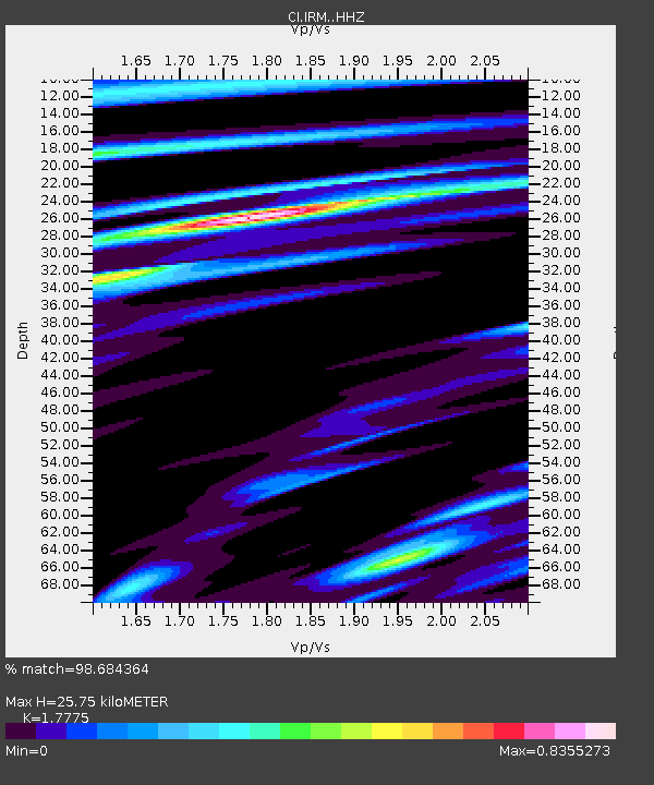
| Estimated Moho Depth: |
25.75 km |
| Estimated Crust Vp/Vs: |
1.78 |
| Assumed Crust Vp: |
6.276 km/s |
| Estimated Crust Vs: |
3.531 km/s |
| Estimated Crust Poisson's Ratio: |
0.27 |
|
| Radial Match: |
98.684364 % |
| Radial Bump: |
322 |
| Transverse Match: |
96.03708 % |
| Transverse Bump: |
400 |
| SOD ConfigId: |
13570011 |
| Insert Time: |
2019-04-30 20:56:33.760 +0000 |
| GWidth: |
2.5 |
| Max Bumps: |
400 |
| Tol: |
0.001 |
|

Signal To Noise
| Channel | StoN | STA | LTA |
| CI:IRM: :HHZ:20180819T00:30:14.108Z | 14.781928 | 2.0194316E-6 | 1.3661489E-7 |
| CI:IRM: :HHN:20180819T00:30:14.108Z | 4.800167 | 3.665302E-7 | 7.63578E-8 |
| CI:IRM: :HHE:20180819T00:30:14.108Z | 11.083768 | 7.692802E-7 | 6.940601E-8 |
| Arrivals |
| Ps | 3.3 SECOND |
| PpPs | 11 SECOND |
| PsPs/PpSs | 14 SECOND |


