You are here: Home > Network List > CI - Caltech Regional Seismic Network Stations List
> Station MUR Murrieta > Earthquake Result Viewer
MUR Murrieta - Earthquake Result Viewer
| Earthquake location: |
Fiji Islands Region |
| Earthquake latitude/longitude: |
-18.2/-178.1 |
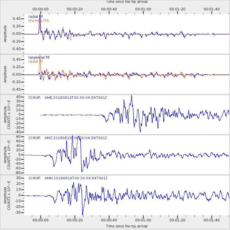
| Earthquake time(UTC): |
2018/08/19 (231) 00:19:37 GMT |
| Earthquake Depth: |
563 km |
| Earthquake Magnitude: |
8.2 mww |
| Earthquake Catalog/Contributor: |
NEIC PDE/us |
|
| Network: |
CI Caltech Regional Seismic Network |
| Station: |
MUR Murrieta |
| Lat/Lon: |
33.60 N/117.20 W |
| Elevation: |
562 m |
|
| Distance: |
77.6 deg |
| Az: |
48.317 deg |
| Baz: |
238.289 deg |
| Ray Param: |
0.04846072 |
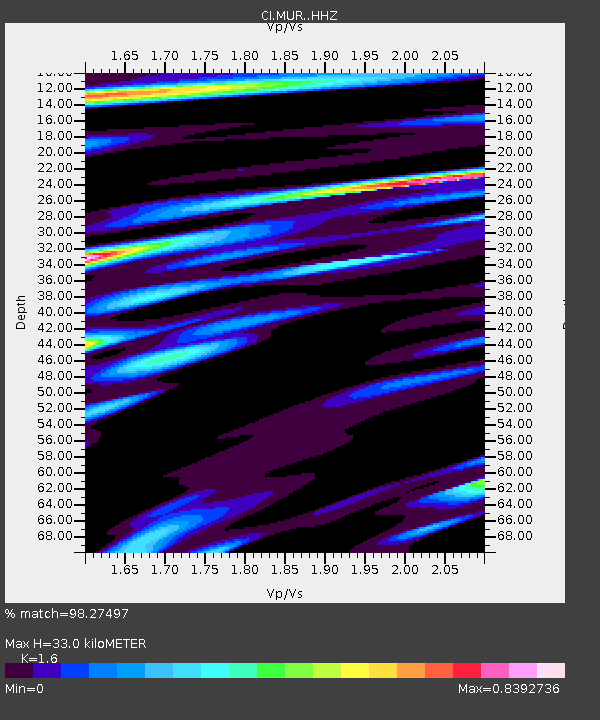
| Estimated Moho Depth: |
33.0 km |
| Estimated Crust Vp/Vs: |
1.60 |
| Assumed Crust Vp: |
6.264 km/s |
| Estimated Crust Vs: |
3.915 km/s |
| Estimated Crust Poisson's Ratio: |
0.18 |
|
| Radial Match: |
98.27497 % |
| Radial Bump: |
400 |
| Transverse Match: |
94.54222 % |
| Transverse Bump: |
400 |
| SOD ConfigId: |
13570011 |
| Insert Time: |
2019-04-30 20:56:41.954 +0000 |
| GWidth: |
2.5 |
| Max Bumps: |
400 |
| Tol: |
0.001 |
|
Signal To Noise
| Channel | StoN | STA | LTA |
| CI:MUR: :HHZ:20180819T00:30:04.847991Z | 28.639679 | 2.120483E-6 | 7.4040045E-8 |
| CI:MUR: :HHN:20180819T00:30:04.847991Z | 4.5324936 | 5.450044E-7 | 1.2024384E-7 |
| CI:MUR: :HHE:20180819T00:30:04.847991Z | 5.980247 | 6.7823953E-7 | 1.134133E-7 |
| Arrivals |
| Ps | 3.3 SECOND |
| PpPs | 13 SECOND |
| PsPs/PpSs | 17 SECOND |


