You are here: Home > Network List > CI - Caltech Regional Seismic Network Stations List
> Station SMM Simmler, CA, USA > Earthquake Result Viewer
SMM Simmler, CA, USA - Earthquake Result Viewer
| Earthquake location: |
Fiji Islands Region |
| Earthquake latitude/longitude: |
-18.2/-178.1 |
| Earthquake time(UTC): |
2018/08/19 (231) 00:19:37 GMT |
| Earthquake Depth: |
563 km |
| Earthquake Magnitude: |
8.2 mww |
| Earthquake Catalog/Contributor: |
NEIC PDE/us |
|
| Network: |
CI Caltech Regional Seismic Network |
| Station: |
SMM Simmler, CA, USA |
| Lat/Lon: |
35.31 N/120.00 W |
| Elevation: |
599 m |
|
| Distance: |
76.6 deg |
| Az: |
45.557 deg |
| Baz: |
236.094 deg |
| Ray Param: |
0.04912765 |
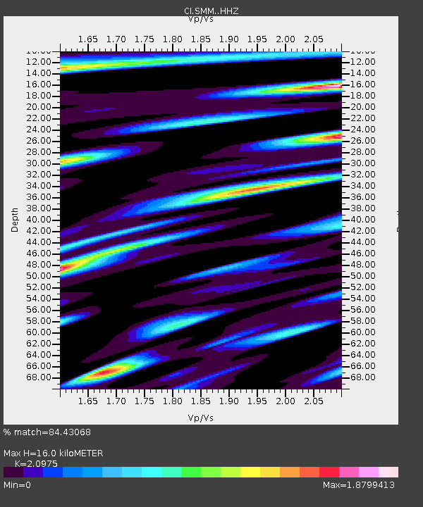
| Estimated Moho Depth: |
16.0 km |
| Estimated Crust Vp/Vs: |
2.10 |
| Assumed Crust Vp: |
6.1 km/s |
| Estimated Crust Vs: |
2.908 km/s |
| Estimated Crust Poisson's Ratio: |
0.35 |
|
| Radial Match: |
84.43068 % |
| Radial Bump: |
400 |
| Transverse Match: |
84.46046 % |
| Transverse Bump: |
400 |
| SOD ConfigId: |
13570011 |
| Insert Time: |
2019-04-30 20:56:53.992 +0000 |
| GWidth: |
2.5 |
| Max Bumps: |
400 |
| Tol: |
0.001 |
|
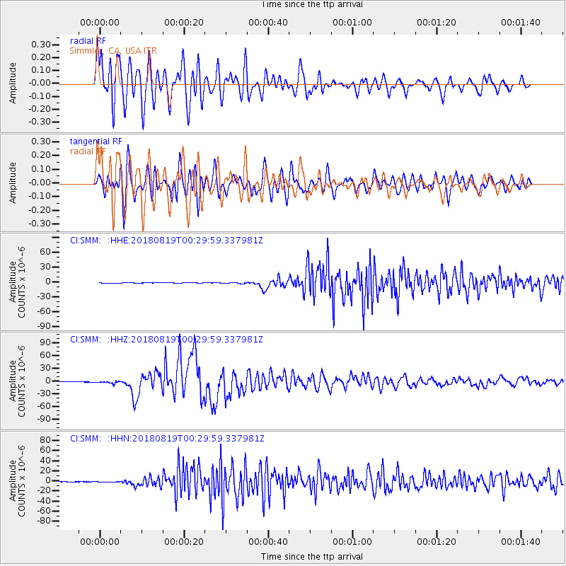
Signal To Noise
| Channel | StoN | STA | LTA |
| CI:SMM: :HHZ:20180819T00:29:59.337981Z | 13.60513 | 2.6519908E-6 | 1.949258E-7 |
| CI:SMM: :HHN:20180819T00:29:59.337981Z | 3.2431228 | 6.494879E-7 | 2.0026621E-7 |
| CI:SMM: :HHE:20180819T00:29:59.337981Z | 3.5256212 | 9.445079E-7 | 2.678983E-7 |
| Arrivals |
| Ps | 2.9 SECOND |
| PpPs | 7.9 SECOND |
| PsPs/PpSs | 11 SECOND |


