You are here: Home > Network List > JP - Japan Meteorological Agency Seismic Network Stations List
> Station YOJ Yonagunijima Island > Earthquake Result Viewer
YOJ Yonagunijima Island - Earthquake Result Viewer
| Earthquake location: |
Fiji Islands Region |
| Earthquake latitude/longitude: |
-18.2/-178.1 |
| Earthquake time(UTC): |
2018/08/19 (231) 00:19:37 GMT |
| Earthquake Depth: |
563 km |
| Earthquake Magnitude: |
8.2 mww |
| Earthquake Catalog/Contributor: |
NEIC PDE/us |
|
| Network: |
JP Japan Meteorological Agency Seismic Network |
| Station: |
YOJ Yonagunijima Island |
| Lat/Lon: |
24.47 N/123.01 E |
| Elevation: |
32 m |
|
| Distance: |
71.3 deg |
| Az: |
304.574 deg |
| Baz: |
120.789 deg |
| Ray Param: |
0.052498326 |
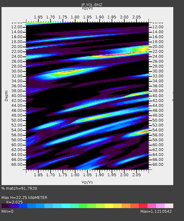
| Estimated Moho Depth: |
22.25 km |
| Estimated Crust Vp/Vs: |
2.03 |
| Assumed Crust Vp: |
6.183 km/s |
| Estimated Crust Vs: |
3.053 km/s |
| Estimated Crust Poisson's Ratio: |
0.34 |
|
| Radial Match: |
91.7928 % |
| Radial Bump: |
400 |
| Transverse Match: |
84.1471 % |
| Transverse Bump: |
400 |
| SOD ConfigId: |
13570011 |
| Insert Time: |
2019-04-30 20:58:23.069 +0000 |
| GWidth: |
2.5 |
| Max Bumps: |
400 |
| Tol: |
0.001 |
|

Signal To Noise
| Channel | StoN | STA | LTA |
| JP:YOJ: :BHZ:20180819T00:29:29.600005Z | 5.12581 | 1.2575319E-5 | 2.4533329E-6 |
| JP:YOJ: :BHN:20180819T00:29:29.600005Z | 1.623479 | 2.3453185E-6 | 1.4446251E-6 |
| JP:YOJ: :BHE:20180819T00:29:29.600005Z | 2.2312384 | 3.3432111E-6 | 1.4983657E-6 |
| Arrivals |
| Ps | 3.8 SECOND |
| PpPs | 11 SECOND |
| PsPs/PpSs | 14 SECOND |


