You are here: Home > Network List > OK - Oklahoma Seismic Network Stations List
> Station CHOK Chandler, Oklahoma, USA > Earthquake Result Viewer
CHOK Chandler, Oklahoma, USA - Earthquake Result Viewer
| Earthquake location: |
Fiji Islands Region |
| Earthquake latitude/longitude: |
-18.2/-178.1 |
| Earthquake time(UTC): |
2018/08/19 (231) 00:19:37 GMT |
| Earthquake Depth: |
563 km |
| Earthquake Magnitude: |
8.2 mww |
| Earthquake Catalog/Contributor: |
NEIC PDE/us |
|
| Network: |
OK Oklahoma Seismic Network |
| Station: |
CHOK Chandler, Oklahoma, USA |
| Lat/Lon: |
35.56 N/97.06 W |
| Elevation: |
338 m |
|
| Distance: |
93.4 deg |
| Az: |
53.786 deg |
| Baz: |
250.181 deg |
| Ray Param: |
0.04077353 |
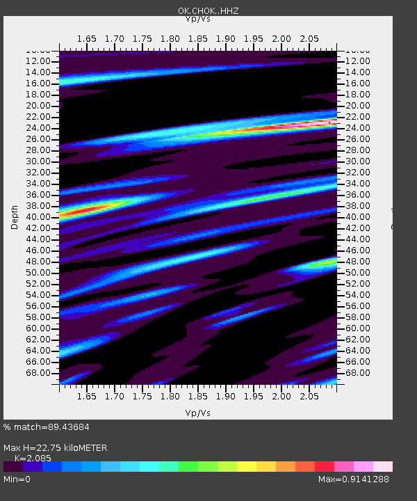
| Estimated Moho Depth: |
22.75 km |
| Estimated Crust Vp/Vs: |
2.09 |
| Assumed Crust Vp: |
6.426 km/s |
| Estimated Crust Vs: |
3.082 km/s |
| Estimated Crust Poisson's Ratio: |
0.35 |
|
| Radial Match: |
89.43684 % |
| Radial Bump: |
400 |
| Transverse Match: |
77.54834 % |
| Transverse Bump: |
400 |
| SOD ConfigId: |
13570011 |
| Insert Time: |
2019-04-30 20:59:31.744 +0000 |
| GWidth: |
2.5 |
| Max Bumps: |
400 |
| Tol: |
0.001 |
|

Signal To Noise
| Channel | StoN | STA | LTA |
| OK:CHOK: :HHZ:20180819T00:31:21.334014Z | 3.903588 | 4.5861339E-7 | 1.1748509E-7 |
| OK:CHOK: :HHN:20180819T00:31:21.334014Z | 2.602897 | 4.410538E-7 | 1.6944729E-7 |
| OK:CHOK: :HHE:20180819T00:31:21.334014Z | 1.1873989 | 2.7122502E-7 | 2.2841947E-7 |
| Arrivals |
| Ps | 3.9 SECOND |
| PpPs | 11 SECOND |
| PsPs/PpSs | 15 SECOND |


