You are here: Home > Network List > TA - USArray Transportable Network (new EarthScope stations) Stations List
> Station F13A Darby, MT, USA > Earthquake Result Viewer
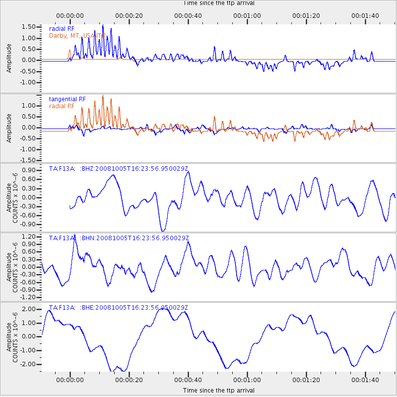
F13A Darby, MT, USA - Earthquake Result Viewer
*The percent match for this event was below the threshold and hence no stack was calculated.
| Earthquake location: |
Tajikistan-Xinjiang Border Reg. |
| Earthquake latitude/longitude: |
39.5/73.9 |
| Earthquake time(UTC): |
2008/10/05 (279) 16:11:10 GMT |
| Earthquake Depth: |
35 km |
| Earthquake Magnitude: |
5.6 MB |
| Earthquake Catalog/Contributor: |
WHDF/NEIC |
|
| Network: |
TA USArray Transportable Network (new EarthScope stations) |
| Station: |
F13A Darby, MT, USA |
| Lat/Lon: |
45.79 N/114.33 W |
| Elevation: |
1462 m |
|
| Distance: |
94.8 deg |
| Az: |
5.761 deg |
| Baz: |
353.628 deg |
| Ray Param: |
$rayparam |
*The percent match for this event was below the threshold and hence was not used in the summary stack. |
|
| Radial Match: |
77.28885 % |
| Radial Bump: |
357 |
| Transverse Match: |
61.990894 % |
| Transverse Bump: |
335 |
| SOD ConfigId: |
2556 |
| Insert Time: |
2010-03-06 14:15:16.345 +0000 |
| GWidth: |
2.5 |
| Max Bumps: |
400 |
| Tol: |
0.001 |
|
Signal To Noise
| Channel | StoN | STA | LTA |
| TA:F13A: :BHN:20081005T16:23:56.950029Z | 1.5935979 | 6.057448E-7 | 3.8011146E-7 |
| TA:F13A: :BHE:20081005T16:23:56.950029Z | 0.7530625 | 6.5630206E-7 | 8.715108E-7 |
| TA:F13A: :BHZ:20081005T16:23:56.950029Z | 2.0658796 | 7.3229535E-7 | 3.5447147E-7 |
| Arrivals |
| Ps | |
| PpPs | |
| PsPs/PpSs | |


