You are here: Home > Network List > TA - USArray Transportable Network (new EarthScope stations) Stations List
> Station C18K Utukok River, AK, USA > Earthquake Result Viewer
C18K Utukok River, AK, USA - Earthquake Result Viewer
| Earthquake location: |
Fiji Islands Region |
| Earthquake latitude/longitude: |
-18.2/-178.1 |
| Earthquake time(UTC): |
2018/08/19 (231) 00:19:37 GMT |
| Earthquake Depth: |
563 km |
| Earthquake Magnitude: |
8.2 mww |
| Earthquake Catalog/Contributor: |
NEIC PDE/us |
|
| Network: |
TA USArray Transportable Network (new EarthScope stations) |
| Station: |
C18K Utukok River, AK, USA |
| Lat/Lon: |
68.65 N/161.19 W |
| Elevation: |
845 m |
|
| Distance: |
87.4 deg |
| Az: |
6.123 deg |
| Baz: |
196.076 deg |
| Ray Param: |
0.04173461 |
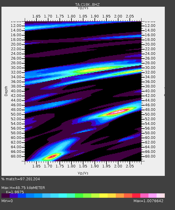
| Estimated Moho Depth: |
48.75 km |
| Estimated Crust Vp/Vs: |
2.00 |
| Assumed Crust Vp: |
5.906 km/s |
| Estimated Crust Vs: |
2.957 km/s |
| Estimated Crust Poisson's Ratio: |
0.33 |
|
| Radial Match: |
97.281204 % |
| Radial Bump: |
400 |
| Transverse Match: |
90.21808 % |
| Transverse Bump: |
400 |
| SOD ConfigId: |
13570011 |
| Insert Time: |
2019-04-30 21:00:58.893 +0000 |
| GWidth: |
2.5 |
| Max Bumps: |
400 |
| Tol: |
0.001 |
|

Signal To Noise
| Channel | StoN | STA | LTA |
| TA:C18K: :BHZ:20180819T00:30:53.875029Z | 3.457478 | 3.4573E-6 | 9.999485E-7 |
| TA:C18K: :BHN:20180819T00:30:53.875029Z | 3.1051097 | 1.4582268E-6 | 4.6962168E-7 |
| TA:C18K: :BHE:20180819T00:30:53.875029Z | 2.5717485 | 5.442524E-7 | 2.116274E-7 |
| Arrivals |
| Ps | 8.4 SECOND |
| PpPs | 24 SECOND |
| PsPs/PpSs | 33 SECOND |


