You are here: Home > Network List > TA - USArray Transportable Network (new EarthScope stations) Stations List
> Station C27K Jago River, AK, USA > Earthquake Result Viewer
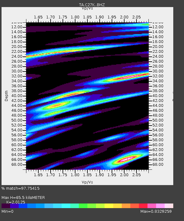
C27K Jago River, AK, USA - Earthquake Result Viewer
| Earthquake location: |
Fiji Islands Region |
| Earthquake latitude/longitude: |
-18.2/-178.1 |
| Earthquake time(UTC): |
2018/08/19 (231) 00:19:37 GMT |
| Earthquake Depth: |
563 km |
| Earthquake Magnitude: |
8.2 mww |
| Earthquake Catalog/Contributor: |
NEIC PDE/us |
|
| Network: |
TA USArray Transportable Network (new EarthScope stations) |
| Station: |
C27K Jago River, AK, USA |
| Lat/Lon: |
69.63 N/143.71 W |
| Elevation: |
392 m |
|
| Distance: |
90.9 deg |
| Az: |
11.413 deg |
| Baz: |
212.492 deg |
| Ray Param: |
0.041341864 |
| Estimated Moho Depth: |
65.5 km |
| Estimated Crust Vp/Vs: |
2.01 |
| Assumed Crust Vp: |
6.522 km/s |
| Estimated Crust Vs: |
3.241 km/s |
| Estimated Crust Poisson's Ratio: |
0.34 |
|
| Radial Match: |
97.75415 % |
| Radial Bump: |
400 |
| Transverse Match: |
91.382996 % |
| Transverse Bump: |
400 |
| SOD ConfigId: |
13570011 |
| Insert Time: |
2019-04-30 21:01:02.473 +0000 |
| GWidth: |
2.5 |
| Max Bumps: |
400 |
| Tol: |
0.001 |
|

Signal To Noise
| Channel | StoN | STA | LTA |
| TA:C27K: :BHZ:20180819T00:31:09.82498Z | 3.780512 | 2.8426127E-6 | 7.5191207E-7 |
| TA:C27K: :BHN:20180819T00:31:09.82498Z | 3.4778817 | 1.0373927E-6 | 2.982829E-7 |
| TA:C27K: :BHE:20180819T00:31:09.82498Z | 3.7997398 | 6.871264E-7 | 1.8083512E-7 |
| Arrivals |
| Ps | 10 SECOND |
| PpPs | 30 SECOND |
| PsPs/PpSs | 40 SECOND |


