You are here: Home > Network List > TA - USArray Transportable Network (new EarthScope stations) Stations List
> Station G23K Bananza Creek, AK, USA > Earthquake Result Viewer
G23K Bananza Creek, AK, USA - Earthquake Result Viewer
| Earthquake location: |
Fiji Islands Region |
| Earthquake latitude/longitude: |
-18.2/-178.1 |
| Earthquake time(UTC): |
2018/08/19 (231) 00:19:37 GMT |
| Earthquake Depth: |
563 km |
| Earthquake Magnitude: |
8.2 mww |
| Earthquake Catalog/Contributor: |
NEIC PDE/us |
|
| Network: |
TA USArray Transportable Network (new EarthScope stations) |
| Station: |
G23K Bananza Creek, AK, USA |
| Lat/Lon: |
66.71 N/150.02 W |
| Elevation: |
746 m |
|
| Distance: |
87.2 deg |
| Az: |
10.803 deg |
| Baz: |
206.625 deg |
| Ray Param: |
0.041911718 |
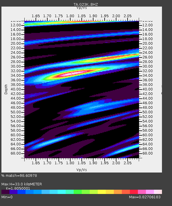
| Estimated Moho Depth: |
33.0 km |
| Estimated Crust Vp/Vs: |
1.81 |
| Assumed Crust Vp: |
6.577 km/s |
| Estimated Crust Vs: |
3.644 km/s |
| Estimated Crust Poisson's Ratio: |
0.28 |
|
| Radial Match: |
98.60978 % |
| Radial Bump: |
400 |
| Transverse Match: |
91.15633 % |
| Transverse Bump: |
400 |
| SOD ConfigId: |
13570011 |
| Insert Time: |
2019-04-30 21:01:36.499 +0000 |
| GWidth: |
2.5 |
| Max Bumps: |
400 |
| Tol: |
0.001 |
|
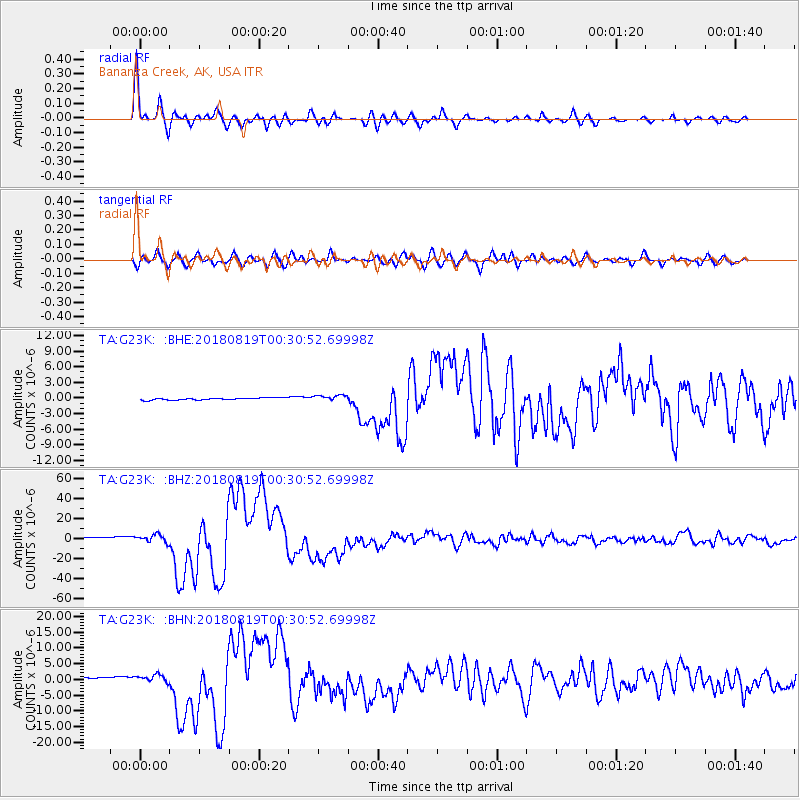
Signal To Noise
| Channel | StoN | STA | LTA |
| TA:G23K: :BHZ:20180819T00:30:52.69998Z | 4.255017 | 3.799991E-6 | 8.930614E-7 |
| TA:G23K: :BHN:20180819T00:30:52.69998Z | 3.3933136 | 1.1933845E-6 | 3.5168705E-7 |
| TA:G23K: :BHE:20180819T00:30:52.69998Z | 2.7449558 | 5.808798E-7 | 2.1161718E-7 |
| Arrivals |
| Ps | 4.1 SECOND |
| PpPs | 14 SECOND |
| PsPs/PpSs | 18 SECOND |


