You are here: Home > Network List > GS - US Geological Survey Networks Stations List
> Station OK032 Salt Plains WLR near Rte 11, Oklahoma, USA > Earthquake Result Viewer
OK032 Salt Plains WLR near Rte 11, Oklahoma, USA - Earthquake Result Viewer
| Earthquake location: |
Northern Mid-Atlantic Ridge |
| Earthquake latitude/longitude: |
22.7/-45.1 |
| Earthquake time(UTC): |
2016/06/21 (173) 16:26:34 GMT |
| Earthquake Depth: |
10 km |
| Earthquake Magnitude: |
6.1 MWB |
| Earthquake Catalog/Contributor: |
NEIC PDE/NEIC COMCAT |
|
| Network: |
GS US Geological Survey Networks |
| Station: |
OK032 Salt Plains WLR near Rte 11, Oklahoma, USA |
| Lat/Lon: |
36.80 N/98.21 W |
| Elevation: |
345 m |
|
| Distance: |
47.6 deg |
| Az: |
299.72 deg |
| Baz: |
91.825 deg |
| Ray Param: |
0.069864705 |
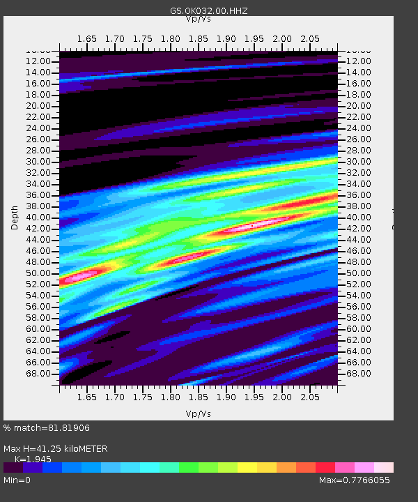
| Estimated Moho Depth: |
41.25 km |
| Estimated Crust Vp/Vs: |
1.95 |
| Assumed Crust Vp: |
6.426 km/s |
| Estimated Crust Vs: |
3.304 km/s |
| Estimated Crust Poisson's Ratio: |
0.32 |
|
| Radial Match: |
81.81906 % |
| Radial Bump: |
400 |
| Transverse Match: |
45.989777 % |
| Transverse Bump: |
400 |
| SOD ConfigId: |
1634031 |
| Insert Time: |
2016-07-05 16:28:23.444 +0000 |
| GWidth: |
2.5 |
| Max Bumps: |
400 |
| Tol: |
0.001 |
|

Signal To Noise
| Channel | StoN | STA | LTA |
| GS:OK032:00:HHZ:20160621T16:34:39.618994Z | 6.976933 | 7.3201005E-7 | 1.04918605E-7 |
| GS:OK032:00:HH1:20160621T16:34:39.618994Z | 0.9891346 | 3.6066157E-7 | 3.6462333E-7 |
| GS:OK032:00:HH2:20160621T16:34:39.618994Z | 1.4699349 | 5.3622784E-7 | 3.64797E-7 |
| Arrivals |
| Ps | 6.4 SECOND |
| PpPs | 18 SECOND |
| PsPs/PpSs | 24 SECOND |


