You are here: Home > Network List > TA - USArray Transportable Network (new EarthScope stations) Stations List
> Station J18K Innoko River, AK, USA > Earthquake Result Viewer
J18K Innoko River, AK, USA - Earthquake Result Viewer
| Earthquake location: |
Fiji Islands Region |
| Earthquake latitude/longitude: |
-18.2/-178.1 |
| Earthquake time(UTC): |
2018/08/19 (231) 00:19:37 GMT |
| Earthquake Depth: |
563 km |
| Earthquake Magnitude: |
8.2 mww |
| Earthquake Catalog/Contributor: |
NEIC PDE/us |
|
| Network: |
TA USArray Transportable Network (new EarthScope stations) |
| Station: |
J18K Innoko River, AK, USA |
| Lat/Lon: |
63.47 N/156.72 W |
| Elevation: |
506 m |
|
| Distance: |
83.1 deg |
| Az: |
9.5 deg |
| Baz: |
200.449 deg |
| Ray Param: |
0.044779982 |
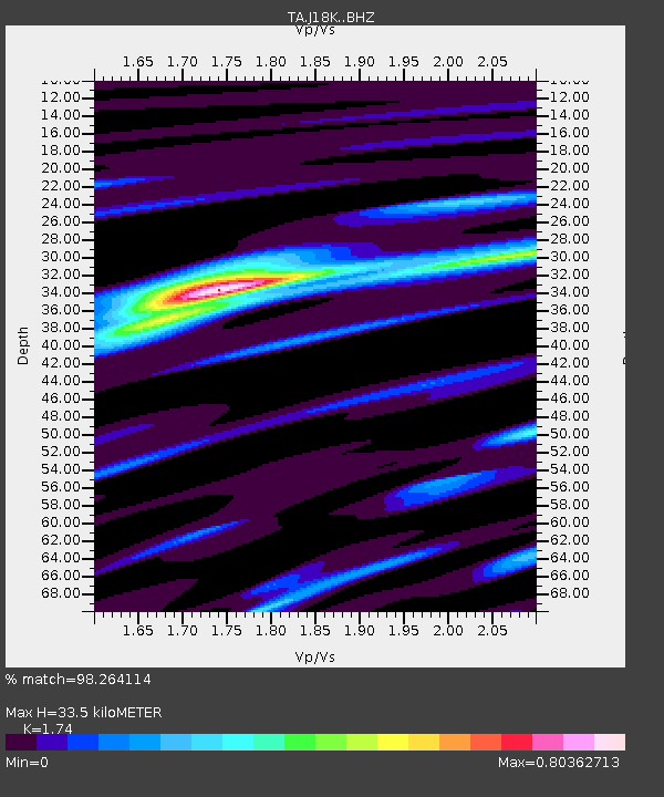
| Estimated Moho Depth: |
33.5 km |
| Estimated Crust Vp/Vs: |
1.74 |
| Assumed Crust Vp: |
6.182 km/s |
| Estimated Crust Vs: |
3.553 km/s |
| Estimated Crust Poisson's Ratio: |
0.25 |
|
| Radial Match: |
98.264114 % |
| Radial Bump: |
344 |
| Transverse Match: |
91.93322 % |
| Transverse Bump: |
400 |
| SOD ConfigId: |
13570011 |
| Insert Time: |
2019-04-30 21:02:01.926 +0000 |
| GWidth: |
2.5 |
| Max Bumps: |
400 |
| Tol: |
0.001 |
|

Signal To Noise
| Channel | StoN | STA | LTA |
| TA:J18K: :BHZ:20180819T00:30:32.94998Z | 6.5285897 | 7.2486773E-6 | 1.1102976E-6 |
| TA:J18K: :BHN:20180819T00:30:32.94998Z | 6.144695 | 2.9120486E-6 | 4.7391262E-7 |
| TA:J18K: :BHE:20180819T00:30:32.94998Z | 4.374357 | 1.0923735E-6 | 2.4972206E-7 |
| Arrivals |
| Ps | 4.1 SECOND |
| PpPs | 15 SECOND |
| PsPs/PpSs | 19 SECOND |


