You are here: Home > Network List > GS - US Geological Survey Networks Stations List
> Station OK033 Mehan, Oklahoma, USA > Earthquake Result Viewer
OK033 Mehan, Oklahoma, USA - Earthquake Result Viewer
| Earthquake location: |
Northern Mid-Atlantic Ridge |
| Earthquake latitude/longitude: |
22.7/-45.1 |
| Earthquake time(UTC): |
2016/06/21 (173) 16:26:34 GMT |
| Earthquake Depth: |
10 km |
| Earthquake Magnitude: |
6.1 MWB |
| Earthquake Catalog/Contributor: |
NEIC PDE/NEIC COMCAT |
|
| Network: |
GS US Geological Survey Networks |
| Station: |
OK033 Mehan, Oklahoma, USA |
| Lat/Lon: |
36.04 N/96.94 W |
| Elevation: |
258 m |
|
| Distance: |
46.6 deg |
| Az: |
298.731 deg |
| Baz: |
91.904 deg |
| Ray Param: |
0.07055481 |
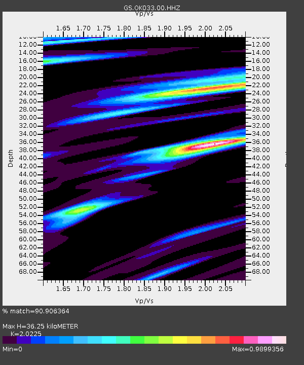
| Estimated Moho Depth: |
36.25 km |
| Estimated Crust Vp/Vs: |
2.02 |
| Assumed Crust Vp: |
6.483 km/s |
| Estimated Crust Vs: |
3.205 km/s |
| Estimated Crust Poisson's Ratio: |
0.34 |
|
| Radial Match: |
90.906364 % |
| Radial Bump: |
400 |
| Transverse Match: |
59.54952 % |
| Transverse Bump: |
400 |
| SOD ConfigId: |
1634031 |
| Insert Time: |
2016-07-05 16:28:25.047 +0000 |
| GWidth: |
2.5 |
| Max Bumps: |
400 |
| Tol: |
0.001 |
|

Signal To Noise
| Channel | StoN | STA | LTA |
| GS:OK033:00:HHZ:20160621T16:34:31.439001Z | 9.774921 | 6.638566E-7 | 6.791427E-8 |
| GS:OK033:00:HH1:20160621T16:34:31.439001Z | 2.8887942 | 2.6461254E-7 | 9.1599645E-8 |
| GS:OK033:00:HH2:20160621T16:34:31.439001Z | 3.5438335 | 4.252246E-7 | 1.1999002E-7 |
| Arrivals |
| Ps | 6.0 SECOND |
| PpPs | 16 SECOND |
| PsPs/PpSs | 22 SECOND |


