You are here: Home > Network List > TA - USArray Transportable Network (new EarthScope stations) Stations List
> Station M11K Mekoryuk, AK, USA > Earthquake Result Viewer
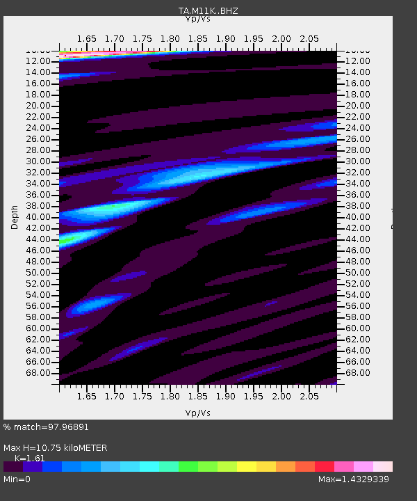
M11K Mekoryuk, AK, USA - Earthquake Result Viewer
| Earthquake location: |
Fiji Islands Region |
| Earthquake latitude/longitude: |
-18.2/-178.1 |
| Earthquake time(UTC): |
2018/08/19 (231) 00:19:37 GMT |
| Earthquake Depth: |
563 km |
| Earthquake Magnitude: |
8.2 mww |
| Earthquake Catalog/Contributor: |
NEIC PDE/us |
|
| Network: |
TA USArray Transportable Network (new EarthScope stations) |
| Station: |
M11K Mekoryuk, AK, USA |
| Lat/Lon: |
60.38 N/166.20 W |
| Elevation: |
3.0 m |
|
| Distance: |
78.9 deg |
| Az: |
5.996 deg |
| Baz: |
191.534 deg |
| Ray Param: |
0.047613133 |
| Estimated Moho Depth: |
10.75 km |
| Estimated Crust Vp/Vs: |
1.61 |
| Assumed Crust Vp: |
6.134 km/s |
| Estimated Crust Vs: |
3.81 km/s |
| Estimated Crust Poisson's Ratio: |
0.19 |
|
| Radial Match: |
97.96891 % |
| Radial Bump: |
400 |
| Transverse Match: |
94.75476 % |
| Transverse Bump: |
400 |
| SOD ConfigId: |
13570011 |
| Insert Time: |
2019-04-30 21:02:19.399 +0000 |
| GWidth: |
2.5 |
| Max Bumps: |
400 |
| Tol: |
0.001 |
|

Signal To Noise
| Channel | StoN | STA | LTA |
| TA:M11K: :BHZ:20180819T00:30:11.44998Z | 5.064015 | 7.5306657E-6 | 1.4870939E-6 |
| TA:M11K: :BHN:20180819T00:30:11.44998Z | 3.1237795 | 3.0221454E-6 | 9.674643E-7 |
| TA:M11K: :BHE:20180819T00:30:11.44998Z | 2.2903056 | 1.2974981E-6 | 5.6651743E-7 |
| Arrivals |
| Ps | 1.1 SECOND |
| PpPs | 4.5 SECOND |
| PsPs/PpSs | 5.5 SECOND |


