You are here: Home > Network List > TA - USArray Transportable Network (new EarthScope stations) Stations List
> Station F14A Wisdom, MT, USA > Earthquake Result Viewer
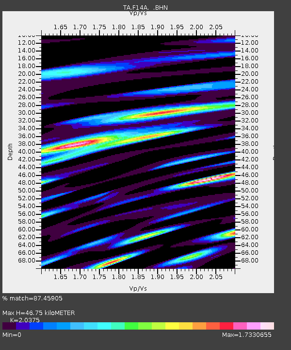
F14A Wisdom, MT, USA - Earthquake Result Viewer
| Earthquake location: |
Eastern Honshu, Japan |
| Earthquake latitude/longitude: |
39.8/141.5 |
| Earthquake time(UTC): |
2008/07/23 (205) 15:26:19 GMT |
| Earthquake Depth: |
108 km |
| Earthquake Magnitude: |
6.6 MB, 6.8 MW, 6.8 MW |
| Earthquake Catalog/Contributor: |
WHDF/NEIC |
|
| Network: |
TA USArray Transportable Network (new EarthScope stations) |
| Station: |
F14A Wisdom, MT, USA |
| Lat/Lon: |
45.81 N/113.37 W |
| Elevation: |
1851 m |
|
| Distance: |
71.7 deg |
| Az: |
45.333 deg |
| Baz: |
308.432 deg |
| Ray Param: |
0.05391267 |
| Estimated Moho Depth: |
46.75 km |
| Estimated Crust Vp/Vs: |
2.04 |
| Assumed Crust Vp: |
6.577 km/s |
| Estimated Crust Vs: |
3.228 km/s |
| Estimated Crust Poisson's Ratio: |
0.34 |
|
| Radial Match: |
87.45905 % |
| Radial Bump: |
400 |
| Transverse Match: |
79.41839 % |
| Transverse Bump: |
400 |
| SOD ConfigId: |
2504 |
| Insert Time: |
2010-03-06 14:16:00.162 +0000 |
| GWidth: |
2.5 |
| Max Bumps: |
400 |
| Tol: |
0.001 |
|

Signal To Noise
| Channel | StoN | STA | LTA |
| TA:F14A: :BHN:20080723T15:36:59.048999Z | 50.73303 | 6.9133503E-6 | 1.3626922E-7 |
| TA:F14A: :BHE:20080723T15:36:59.048999Z | 7.434955 | 2.007633E-6 | 2.7002622E-7 |
| TA:F14A: :BHZ:20080723T15:36:59.048999Z | 9.919201 | 3.6814486E-6 | 3.7114367E-7 |
| Arrivals |
| Ps | 7.6 SECOND |
| PpPs | 21 SECOND |
| PsPs/PpSs | 29 SECOND |


