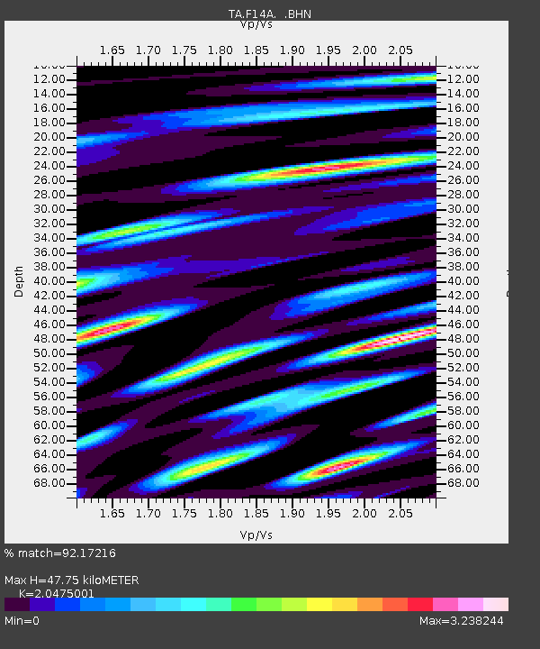
F14A Wisdom, MT, USA - Earthquake Result Viewer

Earthquake location: Rat Islands, Aleutian Islands
Earthquake latitude/longitude: 51.3/179.0
Earthquake time(UTC): 2008/07/25 (207) 00:29:22 GMT
Earthquake Depth: 21 km
Earthquake Magnitude: 5.7 MB, 5.5 MS, 5.9 MW, 5.9 MW
Earthquake Catalog/Contributor: WHDF/NEIC
Network: TA USArray Transportable Network (new EarthScope stations)
Station: F14A Wisdom, MT, USA
Lat/Lon: 45.81 N/113.37 W
Elevation: 1851 m
Distance: 43.7 deg
Az: 69.494 deg
Baz: 302.742 deg
Ray Param: 0.07236513
Estimated Moho Depth: 47.75 km
Estimated Crust Vp/Vs: 2.05
Assumed Crust Vp: 6.577 km/s
Estimated Crust Vs: 3.212 km/s
Estimated Crust Poisson's Ratio: 0.34
Radial Match: 92.17216 %
Radial Bump: 400
Transverse Match: 80.11366 %
Transverse Bump: 400
SOD ConfigId: 2504
Insert Time: 2010-03-06 14:16:03.990 +0000
GWidth: 2.5
Max Bumps: 400
Tol: 0.001

Signal To Noise

ChannelStoNSTALTA
TA:F14A: :BHN:20080725T00:36:55.42401Z17.4414949.192895E-75.270704E-8
TA:F14A: :BHE:20080725T00:36:55.42401Z6.2666355.897526E-79.410993E-8
TA:F14A: :BHZ:20080725T00:36:55.42401Z14.2623729.670118E-76.7801615E-8
Arrivals
Ps8.1 SECOND
PpPs21 SECOND
PsPs/PpSs29 SECOND