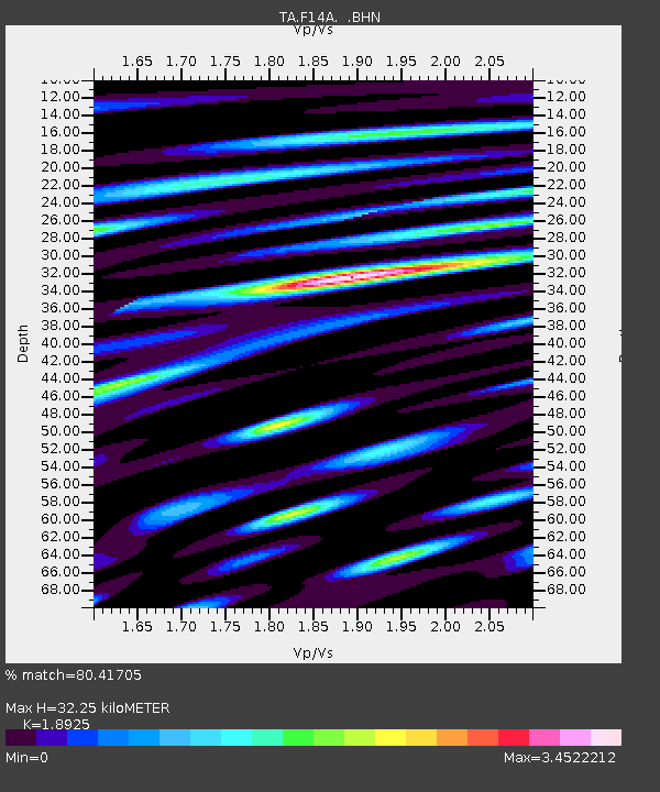
F14A Wisdom, MT, USA - Earthquake Result Viewer
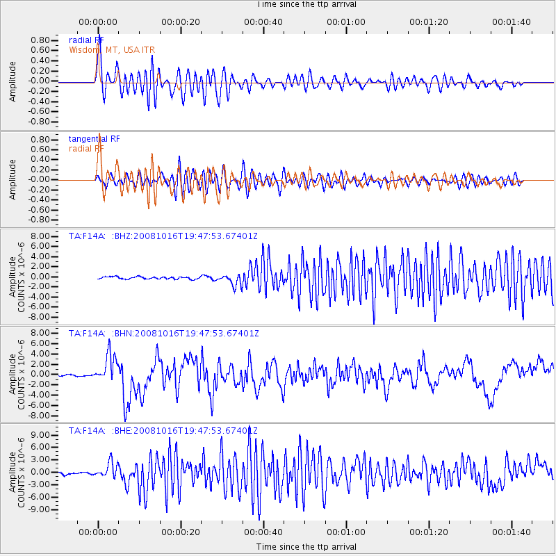
Earthquake location: Near Coast Of Chiapas, Mexico
Earthquake latitude/longitude: 14.4/-92.4
Earthquake time(UTC): 2008/10/16 (290) 19:41:25 GMT
Earthquake Depth: 24 km
Earthquake Magnitude: 6.1 MB, 6.6 MS, 6.7 MW, 6.6 MW
Earthquake Catalog/Contributor: WHDF/NEIC
Network: TA USArray Transportable Network (new EarthScope stations)
Station: F14A Wisdom, MT, USA
Lat/Lon: 45.81 N/113.37 W
Elevation: 1851 m
Distance: 36.0 deg
Az: 334.72 deg
Baz: 143.731 deg
Ray Param: 0.076910034
Estimated Moho Depth: 32.25 km
Estimated Crust Vp/Vs: 1.89
Assumed Crust Vp: 6.577 km/s
Estimated Crust Vs: 3.475 km/s
Estimated Crust Poisson's Ratio: 0.31
Radial Match: 80.41705 %
Radial Bump: 400
Transverse Match: 64.89446 %
Transverse Bump: 400
SOD ConfigId: 2556
Insert Time: 2010-03-06 14:16:18.549 +0000
GWidth: 2.5
Max Bumps: 400
Tol: 0.001

Signal To Noise

ChannelStoNSTALTA
TA:F14A: :BHN:20081016T19:47:53.67401Z21.4637322.8669485E-61.3357176E-7
TA:F14A: :BHE:20081016T19:47:53.67401Z8.1465291.9327877E-62.3725292E-7
TA:F14A: :BHZ:20081016T19:47:53.67401Z5.2525881.1674028E-62.222529E-7
Arrivals
Ps4.7 SECOND
PpPs13 SECOND
PsPs/PpSs18 SECOND