You are here: Home > Network List > TA - USArray Transportable Network (new EarthScope stations) Stations List
> Station F14A Wisdom, MT, USA > Earthquake Result Viewer
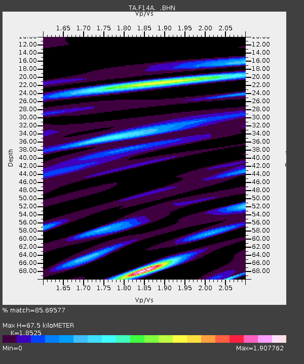
F14A Wisdom, MT, USA - Earthquake Result Viewer
| Earthquake location: |
Kermadec Islands Region |
| Earthquake latitude/longitude: |
-27.4/-176.3 |
| Earthquake time(UTC): |
2009/02/18 (049) 21:53:45 GMT |
| Earthquake Depth: |
25 km |
| Earthquake Magnitude: |
6.8 MB, 7.2 MS, 6.9 MW, 6.9 MW |
| Earthquake Catalog/Contributor: |
WHDF/NEIC |
|
| Network: |
TA USArray Transportable Network (new EarthScope stations) |
| Station: |
F14A Wisdom, MT, USA |
| Lat/Lon: |
45.81 N/113.37 W |
| Elevation: |
1851 m |
|
| Distance: |
92.6 deg |
| Az: |
38.579 deg |
| Baz: |
232.421 deg |
| Ray Param: |
0.04142582 |
| Estimated Moho Depth: |
67.5 km |
| Estimated Crust Vp/Vs: |
1.85 |
| Assumed Crust Vp: |
6.577 km/s |
| Estimated Crust Vs: |
3.55 km/s |
| Estimated Crust Poisson's Ratio: |
0.29 |
|
| Radial Match: |
85.69577 % |
| Radial Bump: |
400 |
| Transverse Match: |
75.39367 % |
| Transverse Bump: |
400 |
| SOD ConfigId: |
2658 |
| Insert Time: |
2010-03-06 14:16:21.098 +0000 |
| GWidth: |
2.5 |
| Max Bumps: |
400 |
| Tol: |
0.001 |
|

Signal To Noise
| Channel | StoN | STA | LTA |
| TA:F14A: :BHN:20090218T22:06:22.800015Z | 7.145382 | 1.218942E-6 | 1.7059158E-7 |
| TA:F14A: :BHE:20090218T22:06:22.800015Z | 1.4063425 | 3.8274507E-7 | 2.7215637E-7 |
| TA:F14A: :BHZ:20090218T22:06:22.800015Z | 1.840104 | 5.4978665E-7 | 2.987802E-7 |
| Arrivals |
| Ps | 8.9 SECOND |
| PpPs | 29 SECOND |
| PsPs/PpSs | 38 SECOND |


