You are here: Home > Network List > TA - USArray Transportable Network (new EarthScope stations) Stations List
> Station T25A Trinidad, CO, USA > Earthquake Result Viewer
T25A Trinidad, CO, USA - Earthquake Result Viewer
| Earthquake location: |
Fiji Islands Region |
| Earthquake latitude/longitude: |
-18.2/-178.1 |
| Earthquake time(UTC): |
2018/08/19 (231) 00:19:37 GMT |
| Earthquake Depth: |
563 km |
| Earthquake Magnitude: |
8.2 mww |
| Earthquake Catalog/Contributor: |
NEIC PDE/us |
|
| Network: |
TA USArray Transportable Network (new EarthScope stations) |
| Station: |
T25A Trinidad, CO, USA |
| Lat/Lon: |
37.14 N/104.41 W |
| Elevation: |
2017 m |
|
| Distance: |
88.5 deg |
| Az: |
50.11 deg |
| Baz: |
245.899 deg |
| Ray Param: |
0.041661162 |
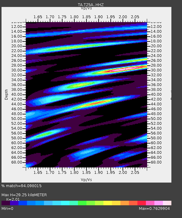
| Estimated Moho Depth: |
29.25 km |
| Estimated Crust Vp/Vs: |
2.01 |
| Assumed Crust Vp: |
6.316 km/s |
| Estimated Crust Vs: |
3.142 km/s |
| Estimated Crust Poisson's Ratio: |
0.34 |
|
| Radial Match: |
94.098015 % |
| Radial Bump: |
400 |
| Transverse Match: |
72.86649 % |
| Transverse Bump: |
400 |
| SOD ConfigId: |
13570011 |
| Insert Time: |
2019-04-30 21:03:12.718 +0000 |
| GWidth: |
2.5 |
| Max Bumps: |
400 |
| Tol: |
0.001 |
|
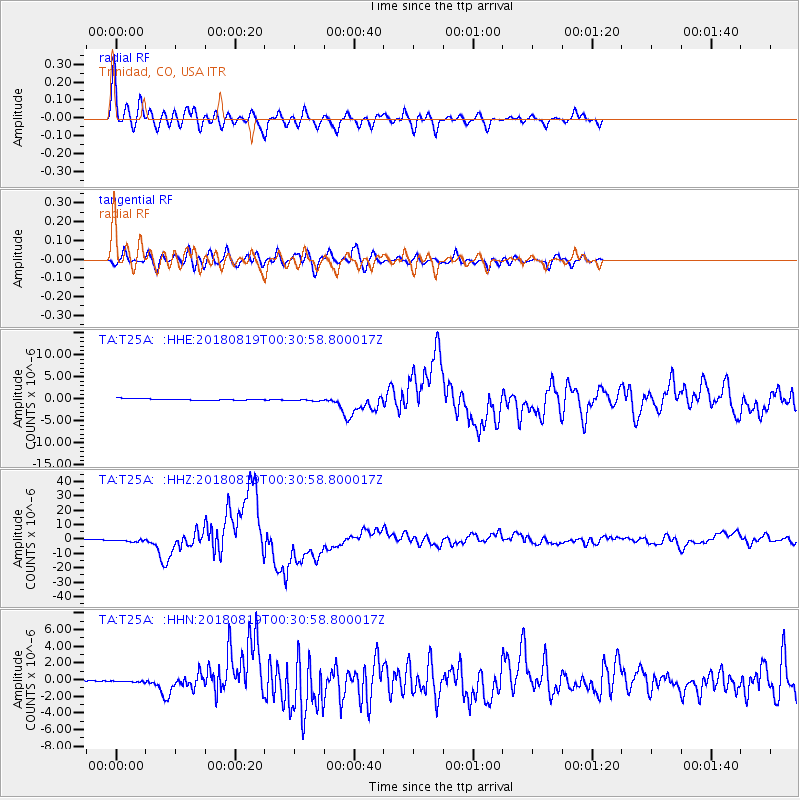
Signal To Noise
| Channel | StoN | STA | LTA |
| TA:T25A: :HHZ:20180819T00:30:58.800017Z | 12.14023 | 9.972991E-7 | 8.214829E-8 |
| TA:T25A: :HHN:20180819T00:30:58.800017Z | 2.6554267 | 1.4060483E-7 | 5.2949993E-8 |
| TA:T25A: :HHE:20180819T00:30:58.800017Z | 1.7449969 | 2.5082E-7 | 1.4373664E-7 |
| Arrivals |
| Ps | 4.8 SECOND |
| PpPs | 14 SECOND |
| PsPs/PpSs | 18 SECOND |


