You are here: Home > Network List > UW - Pacific Northwest Regional Seismic Network Stations List
> Station BLOW Detroit Lake, OR, USA > Earthquake Result Viewer
BLOW Detroit Lake, OR, USA - Earthquake Result Viewer
| Earthquake location: |
Fiji Islands Region |
| Earthquake latitude/longitude: |
-18.2/-178.1 |
| Earthquake time(UTC): |
2018/08/19 (231) 00:19:37 GMT |
| Earthquake Depth: |
563 km |
| Earthquake Magnitude: |
8.2 mww |
| Earthquake Catalog/Contributor: |
NEIC PDE/us |
|
| Network: |
UW Pacific Northwest Regional Seismic Network |
| Station: |
BLOW Detroit Lake, OR, USA |
| Lat/Lon: |
44.68 N/122.19 W |
| Elevation: |
652 m |
|
| Distance: |
80.6 deg |
| Az: |
36.788 deg |
| Baz: |
232.95 deg |
| Ray Param: |
0.04643872 |
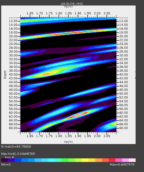
| Estimated Moho Depth: |
61.0 km |
| Estimated Crust Vp/Vs: |
1.90 |
| Assumed Crust Vp: |
6.566 km/s |
| Estimated Crust Vs: |
3.456 km/s |
| Estimated Crust Poisson's Ratio: |
0.31 |
|
| Radial Match: |
94.79808 % |
| Radial Bump: |
363 |
| Transverse Match: |
89.52883 % |
| Transverse Bump: |
400 |
| SOD ConfigId: |
13570011 |
| Insert Time: |
2019-04-30 21:04:07.513 +0000 |
| GWidth: |
2.5 |
| Max Bumps: |
400 |
| Tol: |
0.001 |
|

Signal To Noise
| Channel | StoN | STA | LTA |
| UW:BLOW: :HHZ:20180819T00:30:20.767974Z | 8.650314 | 2.8172085E-6 | 3.25677E-7 |
| UW:BLOW: :HHN:20180819T00:30:20.767974Z | 14.322418 | 1.0711656E-6 | 7.478943E-8 |
| UW:BLOW: :HHE:20180819T00:30:20.767974Z | 8.099922 | 1.2204064E-6 | 1.5066891E-7 |
| Arrivals |
| Ps | 8.6 SECOND |
| PpPs | 26 SECOND |
| PsPs/PpSs | 35 SECOND |


