You are here: Home > Network List > UW - Pacific Northwest Regional Seismic Network Stations List
> Station UMAT Pilot Rock, OR, USA > Earthquake Result Viewer
UMAT Pilot Rock, OR, USA - Earthquake Result Viewer
| Earthquake location: |
Fiji Islands Region |
| Earthquake latitude/longitude: |
-18.2/-178.1 |
| Earthquake time(UTC): |
2018/08/19 (231) 00:19:37 GMT |
| Earthquake Depth: |
563 km |
| Earthquake Magnitude: |
8.2 mww |
| Earthquake Catalog/Contributor: |
NEIC PDE/us |
|
| Network: |
UW Pacific Northwest Regional Seismic Network |
| Station: |
UMAT Pilot Rock, OR, USA |
| Lat/Lon: |
45.29 N/118.96 W |
| Elevation: |
1318 m |
|
| Distance: |
82.8 deg |
| Az: |
37.646 deg |
| Baz: |
235.347 deg |
| Ray Param: |
0.04493663 |
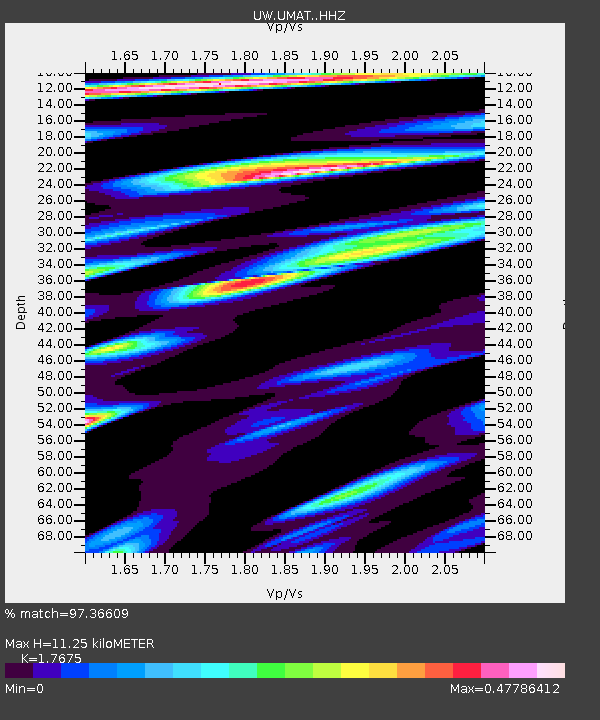
| Estimated Moho Depth: |
11.25 km |
| Estimated Crust Vp/Vs: |
1.77 |
| Assumed Crust Vp: |
6.571 km/s |
| Estimated Crust Vs: |
3.718 km/s |
| Estimated Crust Poisson's Ratio: |
0.26 |
|
| Radial Match: |
97.36609 % |
| Radial Bump: |
368 |
| Transverse Match: |
93.378494 % |
| Transverse Bump: |
400 |
| SOD ConfigId: |
13570011 |
| Insert Time: |
2019-04-30 21:04:40.469 +0000 |
| GWidth: |
2.5 |
| Max Bumps: |
400 |
| Tol: |
0.001 |
|
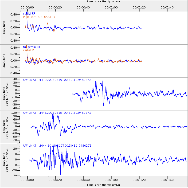
Signal To Noise
| Channel | StoN | STA | LTA |
| UW:UMAT: :HHZ:20180819T00:30:31.948027Z | 12.58363 | 3.2369146E-6 | 2.572322E-7 |
| UW:UMAT: :HHN:20180819T00:30:31.948027Z | 12.205184 | 8.7467623E-7 | 7.1664324E-8 |
| UW:UMAT: :HHE:20180819T00:30:31.948027Z | 9.486722 | 9.595724E-7 | 1.0114899E-7 |
| Arrivals |
| Ps | 1.3 SECOND |
| PpPs | 4.6 SECOND |
| PsPs/PpSs | 6.0 SECOND |


