You are here: Home > Network List > XO18 - AACE: Alaska Amphibious Community seismic Experimen Stations List
> Station EP16 Levelock, AK > Earthquake Result Viewer
EP16 Levelock, AK - Earthquake Result Viewer
| Earthquake location: |
Fiji Islands Region |
| Earthquake latitude/longitude: |
-18.2/-178.1 |
| Earthquake time(UTC): |
2018/08/19 (231) 00:19:37 GMT |
| Earthquake Depth: |
563 km |
| Earthquake Magnitude: |
8.2 mww |
| Earthquake Catalog/Contributor: |
NEIC PDE/us |
|
| Network: |
XO AACE: Alaska Amphibious Community seismic Experimen |
| Station: |
EP16 Levelock, AK |
| Lat/Lon: |
59.11 N/156.86 W |
| Elevation: |
46 m |
|
| Distance: |
79.0 deg |
| Az: |
10.984 deg |
| Baz: |
200.557 deg |
| Ray Param: |
0.047556926 |
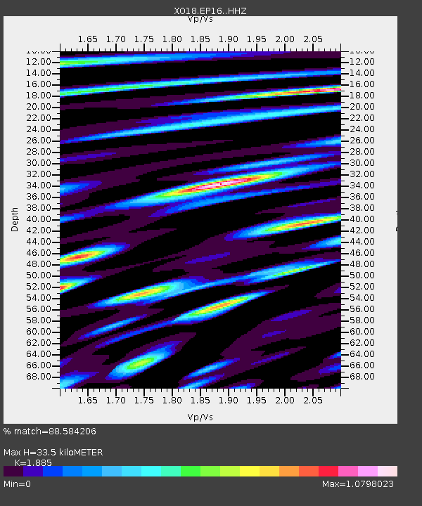
| Estimated Moho Depth: |
33.5 km |
| Estimated Crust Vp/Vs: |
1.88 |
| Assumed Crust Vp: |
6.276 km/s |
| Estimated Crust Vs: |
3.329 km/s |
| Estimated Crust Poisson's Ratio: |
0.30 |
|
| Radial Match: |
88.584206 % |
| Radial Bump: |
400 |
| Transverse Match: |
79.626884 % |
| Transverse Bump: |
400 |
| SOD ConfigId: |
13570011 |
| Insert Time: |
2019-04-30 21:05:04.245 +0000 |
| GWidth: |
2.5 |
| Max Bumps: |
400 |
| Tol: |
0.001 |
|

Signal To Noise
| Channel | StoN | STA | LTA |
| XO:EP16: :HHZ:20180819T00:30:11.899993Z | 10.139815 | 1.3016103E-5 | 1.2836628E-6 |
| XO:EP16: :HHN:20180819T00:30:11.899993Z | 7.458839 | 5.9516105E-6 | 7.979272E-7 |
| XO:EP16: :HHE:20180819T00:30:11.899993Z | 6.200112 | 4.597239E-6 | 7.4147675E-7 |
| Arrivals |
| Ps | 4.8 SECOND |
| PpPs | 15 SECOND |
| PsPs/PpSs | 20 SECOND |


