You are here: Home > Network List > TA - USArray Transportable Network (new EarthScope stations) Stations List
> Station F14A Wisdom, MT, USA > Earthquake Result Viewer
F14A Wisdom, MT, USA - Earthquake Result Viewer

| Earthquake location: |
Kuril Islands |
| Earthquake latitude/longitude: |
45.8/150.1 |
| Earthquake time(UTC): |
2007/09/03 (246) 16:14:53 GMT |
| Earthquake Depth: |
94 km |
| Earthquake Magnitude: |
6.3 MB, 6.2 MW, 6.2 ME |
| Earthquake Catalog/Contributor: |
WHDF/NEIC |
|
| Network: |
TA USArray Transportable Network (new EarthScope stations) |
| Station: |
F14A Wisdom, MT, USA |
| Lat/Lon: |
45.81 N/113.37 W |
| Elevation: |
1851 m |
|
| Distance: |
62.9 deg |
| Az: |
51.288 deg |
| Baz: |
308.742 deg |
| Ray Param: |
0.05965483 |
| Estimated Moho Depth: |
31.25 km |
| Estimated Crust Vp/Vs: |
1.75 |
| Assumed Crust Vp: |
6.577 km/s |
| Estimated Crust Vs: |
3.748 km/s |
| Estimated Crust Poisson's Ratio: |
0.26 |
|
| Radial Match: |
84.79561 % |
| Radial Bump: |
400 |
| Transverse Match: |
78.04349 % |
| Transverse Bump: |
400 |
| SOD ConfigId: |
2564 |
| Insert Time: |
2010-03-06 14:17:14.888 +0000 |
| GWidth: |
2.5 |
| Max Bumps: |
400 |
| Tol: |
0.001 |
|
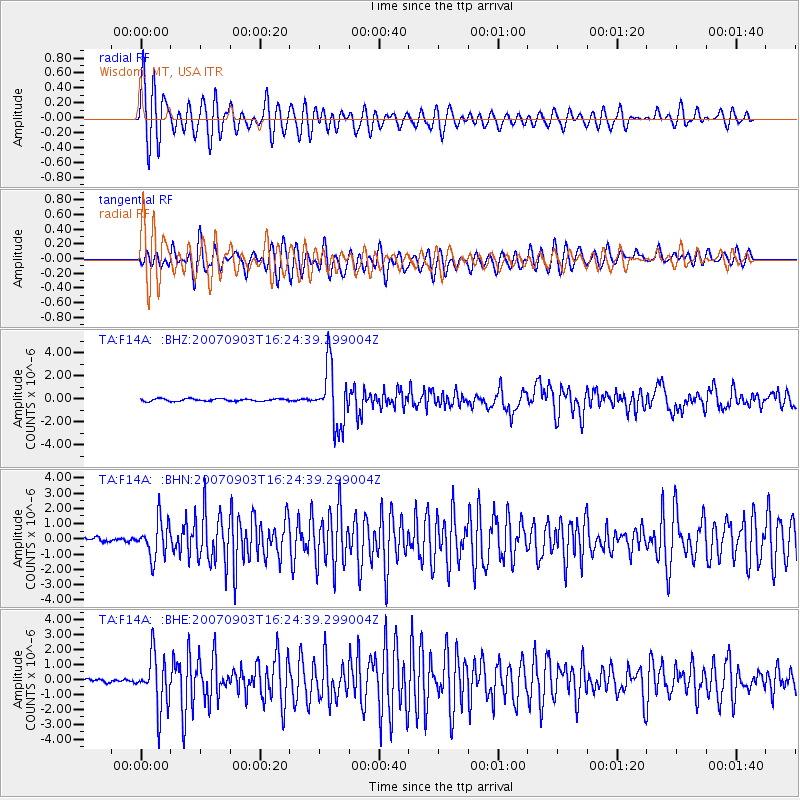
Signal To Noise
| Channel | StoN | STA | LTA |
| TA:F14A: :BHN:20070903T16:24:39.299004Z | 9.049486 | 1.1971008E-6 | 1.3228383E-7 |
| TA:F14A: :BHE:20070903T16:24:39.299004Z | 13.421715 | 1.7667279E-6 | 1.3163205E-7 |
| TA:F14A: :BHZ:20070903T16:24:39.299004Z | 24.221325 | 2.5745794E-6 | 1.0629392E-7 |
| Arrivals |
| Ps | 3.8 SECOND |
| PpPs | 12 SECOND |
| PsPs/PpSs | 16 SECOND |


