You are here: Home > Network List > TA - USArray Transportable Network (new EarthScope stations) Stations List
> Station F14A Wisdom, MT, USA > Earthquake Result Viewer
F14A Wisdom, MT, USA - Earthquake Result Viewer
| Earthquake location: |
Vanuatu Islands |
| Earthquake latitude/longitude: |
-15.6/167.7 |
| Earthquake time(UTC): |
2007/08/01 (213) 17:08:51 GMT |
| Earthquake Depth: |
120 km |
| Earthquake Magnitude: |
6.2 MB, 7.2 MW, 7.2 MW |
| Earthquake Catalog/Contributor: |
WHDF/NEIC |
|
| Network: |
TA USArray Transportable Network (new EarthScope stations) |
| Station: |
F14A Wisdom, MT, USA |
| Lat/Lon: |
45.81 N/113.37 W |
| Elevation: |
1851 m |
|
| Distance: |
93.5 deg |
| Az: |
43.453 deg |
| Baz: |
251.369 deg |
| Ray Param: |
0.04117301 |
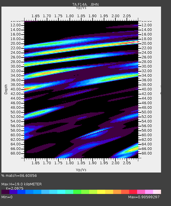
| Estimated Moho Depth: |
19.0 km |
| Estimated Crust Vp/Vs: |
2.10 |
| Assumed Crust Vp: |
6.577 km/s |
| Estimated Crust Vs: |
3.136 km/s |
| Estimated Crust Poisson's Ratio: |
0.35 |
|
| Radial Match: |
86.60856 % |
| Radial Bump: |
400 |
| Transverse Match: |
65.32874 % |
| Transverse Bump: |
400 |
| SOD ConfigId: |
2564 |
| Insert Time: |
2010-03-06 14:17:29.500 +0000 |
| GWidth: |
2.5 |
| Max Bumps: |
400 |
| Tol: |
0.001 |
|
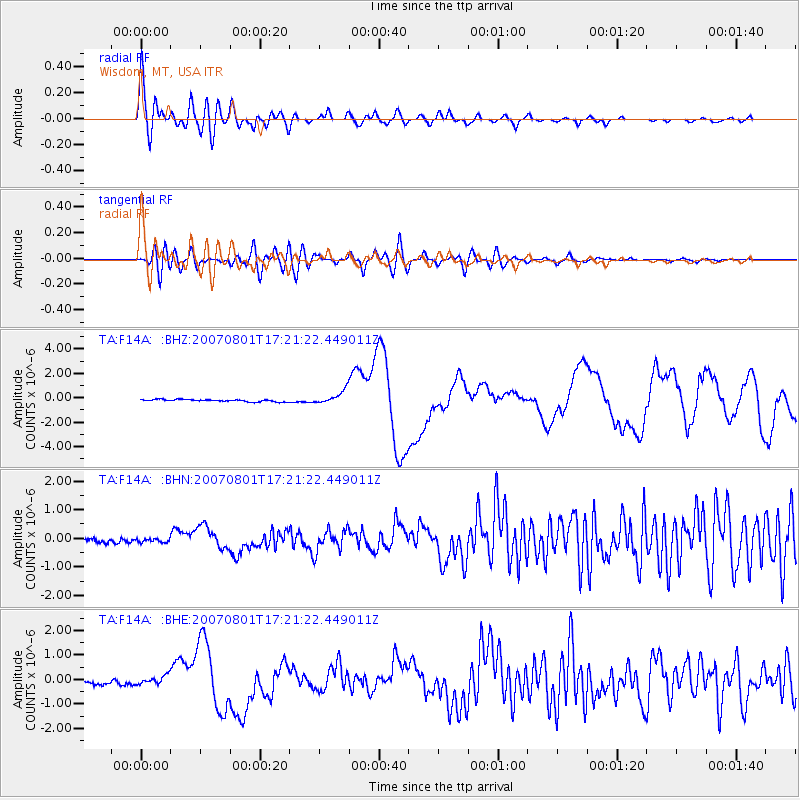
Signal To Noise
| Channel | StoN | STA | LTA |
| TA:F14A: :BHN:20070801T17:21:22.449011Z | 0.62842804 | 7.6659006E-8 | 1.2198534E-7 |
| TA:F14A: :BHE:20070801T17:21:22.449011Z | 1.8637915 | 1.7480772E-7 | 9.379146E-8 |
| TA:F14A: :BHZ:20070801T17:21:22.449011Z | 5.969139 | 5.4590265E-7 | 9.1454176E-8 |
| Arrivals |
| Ps | 3.2 SECOND |
| PpPs | 8.8 SECOND |
| PsPs/PpSs | 12 SECOND |


