You are here: Home > Network List > IW - Intermountain West Stations List
> Station DLMT Dillon, Montana, USA > Earthquake Result Viewer
DLMT Dillon, Montana, USA - Earthquake Result Viewer
| Earthquake location: |
Northern Mid-Atlantic Ridge |
| Earthquake latitude/longitude: |
22.7/-45.1 |
| Earthquake time(UTC): |
2016/06/21 (173) 16:26:34 GMT |
| Earthquake Depth: |
10 km |
| Earthquake Magnitude: |
6.1 MWB |
| Earthquake Catalog/Contributor: |
NEIC PDE/NEIC COMCAT |
|
| Network: |
IW Intermountain West |
| Station: |
DLMT Dillon, Montana, USA |
| Lat/Lon: |
45.36 N/112.60 W |
| Elevation: |
1569 m |
|
| Distance: |
58.6 deg |
| Az: |
310.267 deg |
| Baz: |
88.724 deg |
| Ray Param: |
0.06275058 |
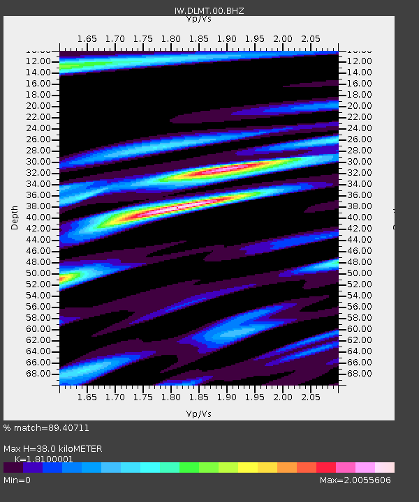
| Estimated Moho Depth: |
38.0 km |
| Estimated Crust Vp/Vs: |
1.81 |
| Assumed Crust Vp: |
6.577 km/s |
| Estimated Crust Vs: |
3.634 km/s |
| Estimated Crust Poisson's Ratio: |
0.28 |
|
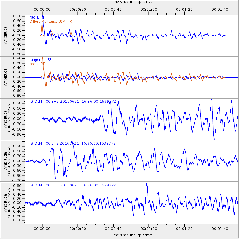
| Radial Match: |
89.40711 % |
| Radial Bump: |
400 |
| Transverse Match: |
79.5151 % |
| Transverse Bump: |
400 |
| SOD ConfigId: |
1634031 |
| Insert Time: |
2016-07-05 16:29:56.868 +0000 |
| GWidth: |
2.5 |
| Max Bumps: |
400 |
| Tol: |
0.001 |
|
Signal To Noise
| Channel | StoN | STA | LTA |
| IW:DLMT:00:BHZ:20160621T16:36:00.163977Z | 6.944551 | 2.012195E-7 | 2.8975165E-8 |
| IW:DLMT:00:BH1:20160621T16:36:00.163977Z | 1.3535255 | 5.7397127E-8 | 4.240565E-8 |
| IW:DLMT:00:BH2:20160621T16:36:00.163977Z | 1.8856277 | 1.5073103E-7 | 7.993679E-8 |
| Arrivals |
| Ps | 4.9 SECOND |
| PpPs | 15 SECOND |
| PsPs/PpSs | 20 SECOND |


