You are here: Home > Network List > TA - USArray Transportable Network (new EarthScope stations) Stations List
> Station F14A Wisdom, MT, USA > Earthquake Result Viewer
F14A Wisdom, MT, USA - Earthquake Result Viewer
| Earthquake location: |
Komandorskiye Ostrova Region |
| Earthquake latitude/longitude: |
53.6/169.7 |
| Earthquake time(UTC): |
2007/07/29 (210) 04:54:36 GMT |
| Earthquake Depth: |
26 km |
| Earthquake Magnitude: |
6.0 MB, 5.5 MS, 5.9 MW, 5.8 MW |
| Earthquake Catalog/Contributor: |
WHDF/NEIC |
|
| Network: |
TA USArray Transportable Network (new EarthScope stations) |
| Station: |
F14A Wisdom, MT, USA |
| Lat/Lon: |
45.81 N/113.37 W |
| Elevation: |
1851 m |
|
| Distance: |
48.1 deg |
| Az: |
66.342 deg |
| Baz: |
308.76 deg |
| Ray Param: |
0.06955999 |
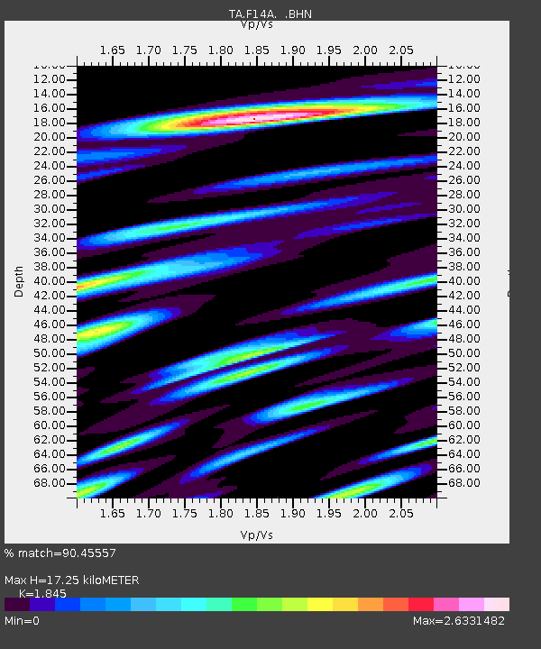
| Estimated Moho Depth: |
17.25 km |
| Estimated Crust Vp/Vs: |
1.85 |
| Assumed Crust Vp: |
6.577 km/s |
| Estimated Crust Vs: |
3.565 km/s |
| Estimated Crust Poisson's Ratio: |
0.29 |
|
| Radial Match: |
90.45557 % |
| Radial Bump: |
400 |
| Transverse Match: |
85.35581 % |
| Transverse Bump: |
400 |
| SOD ConfigId: |
2564 |
| Insert Time: |
2010-03-06 14:17:36.261 +0000 |
| GWidth: |
2.5 |
| Max Bumps: |
400 |
| Tol: |
0.001 |
|
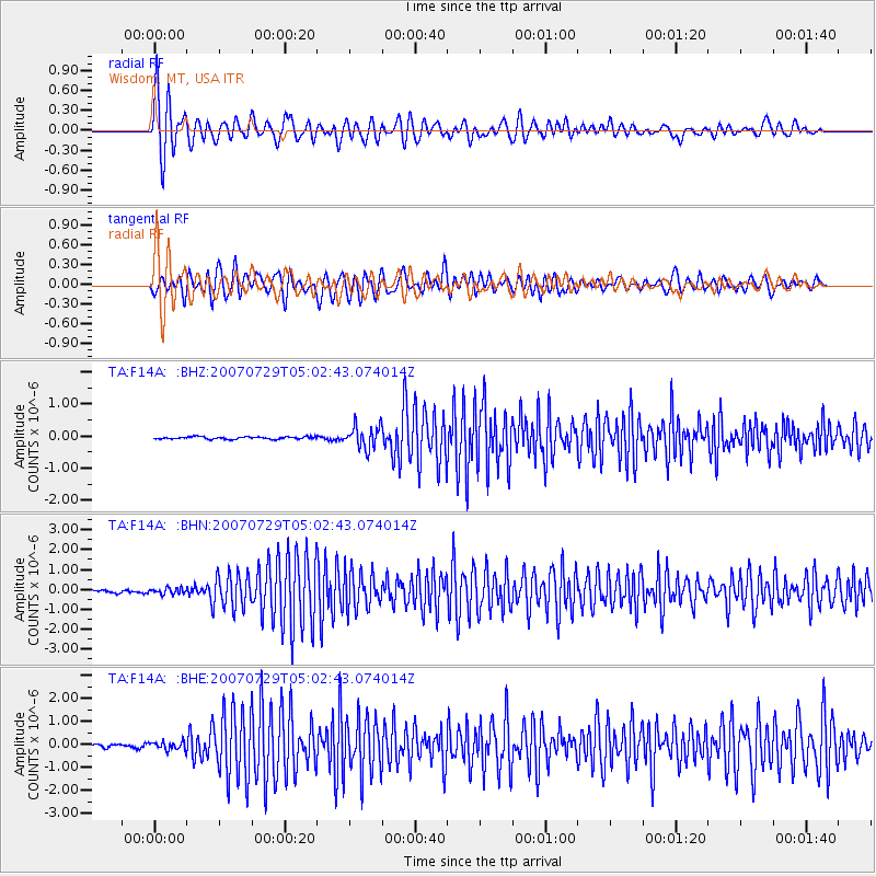
Signal To Noise
| Channel | StoN | STA | LTA |
| TA:F14A: :BHN:20070729T05:02:43.074014Z | 1.9811076 | 1.5330748E-7 | 7.738473E-8 |
| TA:F14A: :BHE:20070729T05:02:43.074014Z | 3.3239582 | 1.8024572E-7 | 5.422623E-8 |
| TA:F14A: :BHZ:20070729T05:02:43.074014Z | 9.460225 | 3.4540375E-7 | 3.6511153E-8 |
| Arrivals |
| Ps | 2.4 SECOND |
| PpPs | 7.0 SECOND |
| PsPs/PpSs | 9.4 SECOND |


