You are here: Home > Network List > C1 - Red Sismologica Nacional Stations List
> Station MT02 Curacavi > Earthquake Result Viewer
MT02 Curacavi - Earthquake Result Viewer
| Earthquake location: |
Fiji Islands Region |
| Earthquake latitude/longitude: |
-18.1/-178.1 |
| Earthquake time(UTC): |
2018/08/19 (231) 00:30:41 GMT |
| Earthquake Depth: |
580 km |
| Earthquake Magnitude: |
5.6 mb |
| Earthquake Catalog/Contributor: |
NEIC PDE/us |
|
| Network: |
C1 Red Sismologica Nacional |
| Station: |
MT02 Curacavi |
| Lat/Lon: |
33.26 S/71.14 W |
| Elevation: |
338 m |
|
| Distance: |
93.7 deg |
| Az: |
126.59 deg |
| Baz: |
245.713 deg |
| Ray Param: |
0.040666584 |
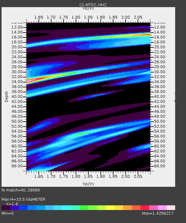
| Estimated Moho Depth: |
33.5 km |
| Estimated Crust Vp/Vs: |
1.60 |
| Assumed Crust Vp: |
6.481 km/s |
| Estimated Crust Vs: |
4.05 km/s |
| Estimated Crust Poisson's Ratio: |
0.18 |
|
| Radial Match: |
81.26968 % |
| Radial Bump: |
400 |
| Transverse Match: |
79.172646 % |
| Transverse Bump: |
400 |
| SOD ConfigId: |
13570011 |
| Insert Time: |
2019-04-30 21:13:14.150 +0000 |
| GWidth: |
2.5 |
| Max Bumps: |
400 |
| Tol: |
0.001 |
|

Signal To Noise
| Channel | StoN | STA | LTA |
| C1:MT02: :HHZ:20180819T00:42:25.839983Z | 1.2780454 | 1.4395576E-5 | 1.12637435E-5 |
| C1:MT02: :HHN:20180819T00:42:25.839983Z | 1.6877172 | 4.837498E-5 | 2.8662964E-5 |
| C1:MT02: :HHE:20180819T00:42:25.839983Z | 0.9754024 | 1.8853763E-5 | 1.9329216E-5 |
| Arrivals |
| Ps | 3.2 SECOND |
| PpPs | 13 SECOND |
| PsPs/PpSs | 16 SECOND |


