You are here: Home > Network List > TA - USArray Transportable Network (new EarthScope stations) Stations List
> Station F14A Wisdom, MT, USA > Earthquake Result Viewer
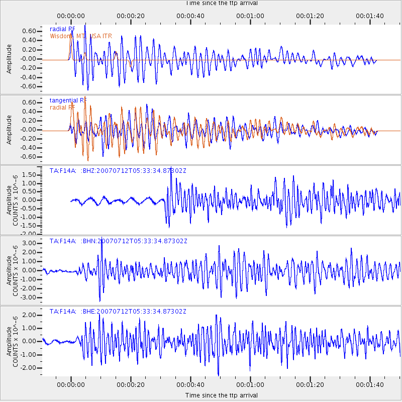
F14A Wisdom, MT, USA - Earthquake Result Viewer

| Earthquake location: |
Peru-Brazil Border Region |
| Earthquake latitude/longitude: |
-7.9/-74.4 |
| Earthquake time(UTC): |
2007/07/12 (193) 05:23:49 GMT |
| Earthquake Depth: |
152 km |
| Earthquake Magnitude: |
5.9 MB, 6.1 MW, 6.0 MW |
| Earthquake Catalog/Contributor: |
WHDF/NEIC |
|
| Network: |
TA USArray Transportable Network (new EarthScope stations) |
| Station: |
F14A Wisdom, MT, USA |
| Lat/Lon: |
45.81 N/113.37 W |
| Elevation: |
1851 m |
|
| Distance: |
63.9 deg |
| Az: |
330.647 deg |
| Baz: |
136.034 deg |
| Ray Param: |
0.058855947 |
| Estimated Moho Depth: |
29.25 km |
| Estimated Crust Vp/Vs: |
2.07 |
| Assumed Crust Vp: |
6.577 km/s |
| Estimated Crust Vs: |
3.185 km/s |
| Estimated Crust Poisson's Ratio: |
0.35 |
|
| Radial Match: |
84.6652 % |
| Radial Bump: |
400 |
| Transverse Match: |
77.79473 % |
| Transverse Bump: |
400 |
| SOD ConfigId: |
2564 |
| Insert Time: |
2010-03-06 14:17:48.627 +0000 |
| GWidth: |
2.5 |
| Max Bumps: |
400 |
| Tol: |
0.001 |
|
Signal To Noise
| Channel | StoN | STA | LTA |
| TA:F14A: :BHN:20070712T05:33:34.87302Z | 2.0091152 | 2.6801885E-7 | 1.3340144E-7 |
| TA:F14A: :BHE:20070712T05:33:34.87302Z | 3.4980462 | 4.590408E-7 | 1.3122776E-7 |
| TA:F14A: :BHZ:20070712T05:33:34.87302Z | 6.1944184 | 7.210015E-7 | 1.1639535E-7 |
| Arrivals |
| Ps | 4.9 SECOND |
| PpPs | 13 SECOND |
| PsPs/PpSs | 18 SECOND |


