You are here: Home > Network List > TA - USArray Transportable Network (new EarthScope stations) Stations List
> Station F14A Wisdom, MT, USA > Earthquake Result Viewer
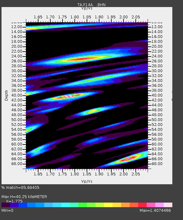
F14A Wisdom, MT, USA - Earthquake Result Viewer
| Earthquake location: |
Central Mid-Atlantic Ridge |
| Earthquake latitude/longitude: |
0.7/-30.3 |
| Earthquake time(UTC): |
2007/07/03 (184) 08:26:00 GMT |
| Earthquake Depth: |
10 km |
| Earthquake Magnitude: |
5.8 MB, 5.9 MS, 6.3 MW, 6.1 MW |
| Earthquake Catalog/Contributor: |
WHDF/NEIC |
|
| Network: |
TA USArray Transportable Network (new EarthScope stations) |
| Station: |
F14A Wisdom, MT, USA |
| Lat/Lon: |
45.81 N/113.37 W |
| Elevation: |
1851 m |
|
| Distance: |
84.7 deg |
| Az: |
315.784 deg |
| Baz: |
94.448 deg |
| Ray Param: |
0.045316864 |
| Estimated Moho Depth: |
40.25 km |
| Estimated Crust Vp/Vs: |
1.77 |
| Assumed Crust Vp: |
6.577 km/s |
| Estimated Crust Vs: |
3.705 km/s |
| Estimated Crust Poisson's Ratio: |
0.27 |
|
| Radial Match: |
85.66405 % |
| Radial Bump: |
400 |
| Transverse Match: |
89.59953 % |
| Transverse Bump: |
400 |
| SOD ConfigId: |
2564 |
| Insert Time: |
2010-03-06 14:17:50.851 +0000 |
| GWidth: |
2.5 |
| Max Bumps: |
400 |
| Tol: |
0.001 |
|

Signal To Noise
| Channel | StoN | STA | LTA |
| TA:F14A: :BHN:20070703T08:38:03.150027Z | 1.1923577 | 1.1858317E-7 | 9.945269E-8 |
| TA:F14A: :BHE:20070703T08:38:03.150027Z | 2.624318 | 2.008241E-7 | 7.652431E-8 |
| TA:F14A: :BHZ:20070703T08:38:03.150027Z | 3.6815085 | 3.406842E-7 | 9.2539295E-8 |
| Arrivals |
| Ps | 4.9 SECOND |
| PpPs | 17 SECOND |
| PsPs/PpSs | 21 SECOND |


