You are here: Home > Network List > TA - USArray Transportable Network (new EarthScope stations) Stations List
> Station D23K Nanushuk River, AK USA > Earthquake Result Viewer
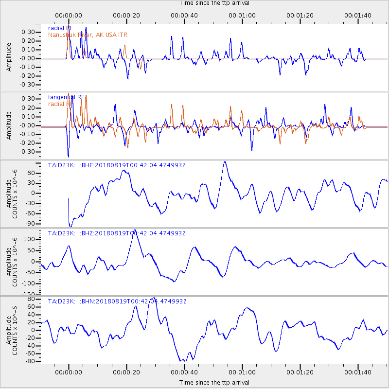
D23K Nanushuk River, AK USA - Earthquake Result Viewer
*The percent match for this event was below the threshold and hence no stack was calculated.
| Earthquake location: |
Fiji Islands Region |
| Earthquake latitude/longitude: |
-18.1/-178.1 |
| Earthquake time(UTC): |
2018/08/19 (231) 00:30:41 GMT |
| Earthquake Depth: |
580 km |
| Earthquake Magnitude: |
5.6 mb |
| Earthquake Catalog/Contributor: |
NEIC PDE/us |
|
| Network: |
TA USArray Transportable Network (new EarthScope stations) |
| Station: |
D23K Nanushuk River, AK USA |
| Lat/Lon: |
68.97 N/150.68 W |
| Elevation: |
406 m |
|
| Distance: |
89.0 deg |
| Az: |
9.586 deg |
| Baz: |
206.023 deg |
| Ray Param: |
$rayparam |
*The percent match for this event was below the threshold and hence was not used in the summary stack. |
|
| Radial Match: |
79.69044 % |
| Radial Bump: |
400 |
| Transverse Match: |
35.75151 % |
| Transverse Bump: |
359 |
| SOD ConfigId: |
13570011 |
| Insert Time: |
2019-04-30 21:15:41.470 +0000 |
| GWidth: |
2.5 |
| Max Bumps: |
400 |
| Tol: |
0.001 |
|
Signal To Noise
| Channel | StoN | STA | LTA |
| TA:D23K: :BHZ:20180819T00:42:04.474993Z | 2.6630285 | 4.38343E-5 | 1.6460319E-5 |
| TA:D23K: :BHN:20180819T00:42:04.474993Z | 0.29051852 | 8.848266E-6 | 3.0456804E-5 |
| TA:D23K: :BHE:20180819T00:42:04.474993Z | 0.90978503 | 4.3054773E-5 | 4.7324116E-5 |
| Arrivals |
| Ps | |
| PpPs | |
| PsPs/PpSs | |


