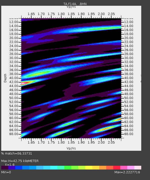
F14A Wisdom, MT, USA - Earthquake Result Viewer
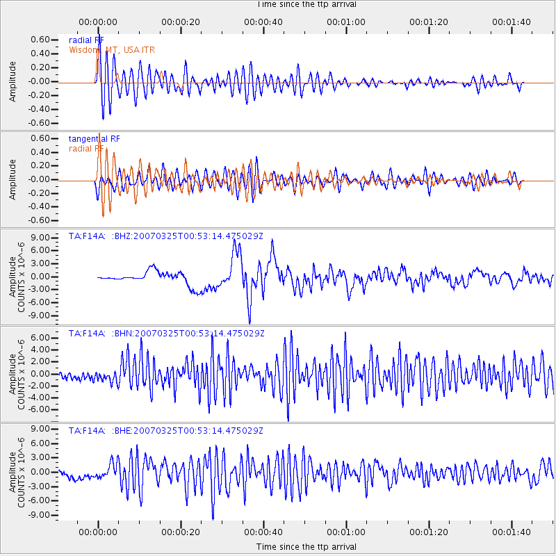
Earthquake location: Near West Coast Of Honshu, Japan
Earthquake latitude/longitude: 37.3/136.6
Earthquake time(UTC): 2007/03/25 (084) 00:41:57 GMT
Earthquake Depth: 8.0 km
Earthquake Magnitude: 6.1 MB, 6.8 MS, 6.7 MW, 6.6 MW
Earthquake Catalog/Contributor: WHDF/NEIC
Network: TA USArray Transportable Network (new EarthScope stations)
Station: F14A Wisdom, MT, USA
Lat/Lon: 45.81 N/113.37 W
Elevation: 1851 m
Distance: 76.1 deg
Az: 42.605 deg
Baz: 309.517 deg
Ray Param: 0.051239286
Estimated Moho Depth: 42.75 km
Estimated Crust Vp/Vs: 1.60
Assumed Crust Vp: 6.577 km/s
Estimated Crust Vs: 4.111 km/s
Estimated Crust Poisson's Ratio: 0.18
Radial Match: 86.33731 %
Radial Bump: 400
Transverse Match: 76.48405 %
Transverse Bump: 400
SOD ConfigId: 2564
Insert Time: 2010-03-06 14:17:59.318 +0000
GWidth: 2.5
Max Bumps: 400
Tol: 0.001

Signal To Noise

ChannelStoNSTALTA
TA:F14A: :BHN:20070325T00:53:14.475029Z3.00671159.210315E-73.063252E-7
TA:F14A: :BHE:20070325T00:53:14.475029Z2.95060041.602475E-65.4310135E-7
TA:F14A: :BHZ:20070325T00:53:14.475029Z2.94328474.4124513E-61.4991588E-6
Arrivals
Ps4.0 SECOND
PpPs16 SECOND
PsPs/PpSs20 SECOND