You are here: Home > Network List > TA - USArray Transportable Network (new EarthScope stations) Stations List
> Station F14A Wisdom, MT, USA > Earthquake Result Viewer
F14A Wisdom, MT, USA - Earthquake Result Viewer
| Earthquake location: |
East Of Kuril Islands |
| Earthquake latitude/longitude: |
46.2/154.4 |
| Earthquake time(UTC): |
2006/12/07 (341) 19:10:21 GMT |
| Earthquake Depth: |
16 km |
| Earthquake Magnitude: |
6.3 MB, 6.1 MS, 6.3 MW, 6.3 MW |
| Earthquake Catalog/Contributor: |
WHDF/NEIC |
|
| Network: |
TA USArray Transportable Network (new EarthScope stations) |
| Station: |
F14A Wisdom, MT, USA |
| Lat/Lon: |
45.81 N/113.37 W |
| Elevation: |
1851 m |
|
| Distance: |
60.3 deg |
| Az: |
53.533 deg |
| Baz: |
306.937 deg |
| Ray Param: |
0.061578855 |
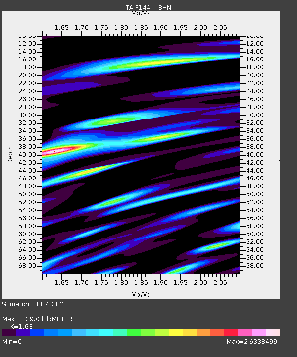
| Estimated Moho Depth: |
39.0 km |
| Estimated Crust Vp/Vs: |
1.63 |
| Assumed Crust Vp: |
6.577 km/s |
| Estimated Crust Vs: |
4.035 km/s |
| Estimated Crust Poisson's Ratio: |
0.20 |
|
| Radial Match: |
88.73382 % |
| Radial Bump: |
400 |
| Transverse Match: |
81.786156 % |
| Transverse Bump: |
400 |
| SOD ConfigId: |
2564 |
| Insert Time: |
2010-03-06 14:18:04.763 +0000 |
| GWidth: |
2.5 |
| Max Bumps: |
400 |
| Tol: |
0.001 |
|

Signal To Noise
| Channel | StoN | STA | LTA |
| TA:F14A: :BHN:20061207T19:19:58.823022Z | 1.8993894 | 6.3827304E-7 | 3.3604115E-7 |
| TA:F14A: :BHE:20061207T19:19:58.823022Z | 2.1006145 | 9.632856E-7 | 4.585732E-7 |
| TA:F14A: :BHZ:20061207T19:19:58.823022Z | 2.4203713 | 1.0910692E-6 | 4.5078585E-7 |
| Arrivals |
| Ps | 3.9 SECOND |
| PpPs | 15 SECOND |
| PsPs/PpSs | 19 SECOND |


