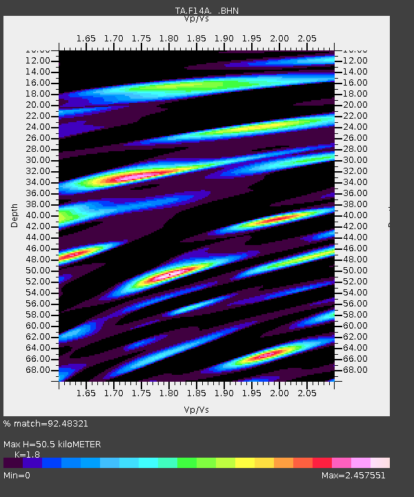
F14A Wisdom, MT, USA - Earthquake Result Viewer

Earthquake location: Andreanof Islands, Aleutian Is.
Earthquake latitude/longitude: 51.9/-177.5
Earthquake time(UTC): 2008/05/02 (123) 01:33:37 GMT
Earthquake Depth: 14 km
Earthquake Magnitude: 6.3 MB, 6.8 MS, 6.6 MW, 6.6 MW
Earthquake Catalog/Contributor: WHDF/NEIC
Network: TA USArray Transportable Network (new EarthScope stations)
Station: F14A Wisdom, MT, USA
Lat/Lon: 45.81 N/113.37 W
Elevation: 1851 m
Distance: 41.4 deg
Az: 72.042 deg
Baz: 302.499 deg
Ray Param: 0.07378605
Estimated Moho Depth: 50.5 km
Estimated Crust Vp/Vs: 1.80
Assumed Crust Vp: 6.577 km/s
Estimated Crust Vs: 3.654 km/s
Estimated Crust Poisson's Ratio: 0.28
Radial Match: 92.48321 %
Radial Bump: 400
Transverse Match: 80.416145 %
Transverse Bump: 400
SOD ConfigId: 2504
Insert Time: 2010-03-06 14:18:15.779 +0000
GWidth: 2.5
Max Bumps: 400
Tol: 0.001

Signal To Noise

ChannelStoNSTALTA
TA:F14A: :BHN:20080502T01:40:52.37501Z14.1213121.4077616E-69.9690574E-8
TA:F14A: :BHE:20080502T01:40:52.37501Z2.26488284.6061677E-72.0337333E-7
TA:F14A: :BHZ:20080502T01:40:52.37501Z7.26280748.8021005E-71.2119419E-7
Arrivals
Ps6.6 SECOND
PpPs20 SECOND
PsPs/PpSs27 SECOND