You are here: Home > Network List > NE - New England Seismic Network Stations List
> Station WSPT Westport, CT, USA > Earthquake Result Viewer
WSPT Westport, CT, USA - Earthquake Result Viewer
| Earthquake location: |
Northern Mid-Atlantic Ridge |
| Earthquake latitude/longitude: |
22.7/-45.1 |
| Earthquake time(UTC): |
2016/06/21 (173) 16:26:34 GMT |
| Earthquake Depth: |
10 km |
| Earthquake Magnitude: |
6.1 MWB |
| Earthquake Catalog/Contributor: |
NEIC PDE/NEIC COMCAT |
|
| Network: |
NE New England Seismic Network |
| Station: |
WSPT Westport, CT, USA |
| Lat/Lon: |
41.17 N/73.33 W |
| Elevation: |
91 m |
|
| Distance: |
30.0 deg |
| Az: |
314.53 deg |
| Baz: |
119.278 deg |
| Ray Param: |
0.07944111 |
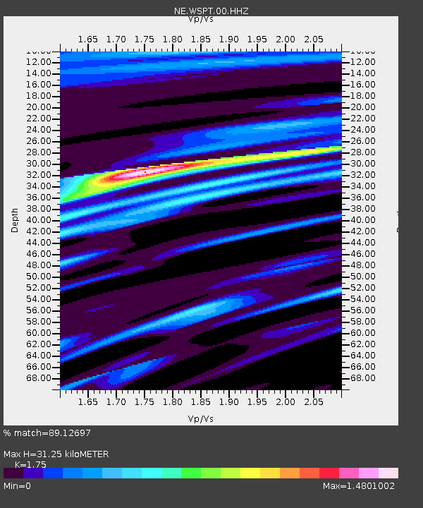
| Estimated Moho Depth: |
31.25 km |
| Estimated Crust Vp/Vs: |
1.75 |
| Assumed Crust Vp: |
6.472 km/s |
| Estimated Crust Vs: |
3.698 km/s |
| Estimated Crust Poisson's Ratio: |
0.26 |
|
| Radial Match: |
89.12697 % |
| Radial Bump: |
400 |
| Transverse Match: |
46.559143 % |
| Transverse Bump: |
400 |
| SOD ConfigId: |
1634031 |
| Insert Time: |
2016-07-05 16:30:51.594 +0000 |
| GWidth: |
2.5 |
| Max Bumps: |
400 |
| Tol: |
0.001 |
|

Signal To Noise
| Channel | StoN | STA | LTA |
| NE:WSPT:00:HHZ:20160621T16:32:12.639014Z | 3.0874684 | 7.69834E-7 | 2.493415E-7 |
| NE:WSPT:00:HH1:20160621T16:32:12.639014Z | 1.5582843 | 3.0667027E-7 | 1.9679996E-7 |
| NE:WSPT:00:HH2:20160621T16:32:12.639014Z | 2.1209357 | 4.0498625E-7 | 1.9094698E-7 |
| Arrivals |
| Ps | 3.9 SECOND |
| PpPs | 12 SECOND |
| PsPs/PpSs | 16 SECOND |


