You are here: Home > Network List > AV - Alaska Volcano Observatory Stations List
> Station PLBL Mt. Peulik Volcano, Alaska > Earthquake Result Viewer
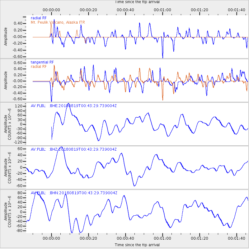
PLBL Mt. Peulik Volcano, Alaska - Earthquake Result Viewer
*The percent match for this event was below the threshold and hence no stack was calculated.
| Earthquake location: |
Fiji Islands Region |
| Earthquake latitude/longitude: |
-17.9/-178.2 |
| Earthquake time(UTC): |
2018/08/19 (231) 00:32:59 GMT |
| Earthquake Depth: |
520 km |
| Earthquake Magnitude: |
5.7 mb |
| Earthquake Catalog/Contributor: |
NEIC PDE/us |
|
| Network: |
AV Alaska Volcano Observatory |
| Station: |
PLBL Mt. Peulik Volcano, Alaska |
| Lat/Lon: |
57.70 N/156.82 W |
| Elevation: |
461 m |
|
| Distance: |
77.4 deg |
| Az: |
11.569 deg |
| Baz: |
200.827 deg |
| Ray Param: |
$rayparam |
*The percent match for this event was below the threshold and hence was not used in the summary stack. |
|
| Radial Match: |
57.07465 % |
| Radial Bump: |
400 |
| Transverse Match: |
33.518356 % |
| Transverse Bump: |
400 |
| SOD ConfigId: |
13570011 |
| Insert Time: |
2019-04-30 21:19:06.064 +0000 |
| GWidth: |
2.5 |
| Max Bumps: |
400 |
| Tol: |
0.001 |
|
Signal To Noise
| Channel | StoN | STA | LTA |
| AV:PLBL: :BHZ:20180819T00:43:29.739004Z | 3.1234052 | 3.977505E-5 | 1.2734515E-5 |
| AV:PLBL: :BHN:20180819T00:43:29.739004Z | 0.77109194 | 3.7540143E-5 | 4.8684393E-5 |
| AV:PLBL: :BHE:20180819T00:43:29.739004Z | 1.07847 | 6.106524E-5 | 5.6622102E-5 |
| Arrivals |
| Ps | |
| PpPs | |
| PsPs/PpSs | |


