You are here: Home > Network List > TA - USArray Transportable Network (new EarthScope stations) Stations List
> Station 109C Camp Elliot, Mirimar, CA, USA > Earthquake Result Viewer
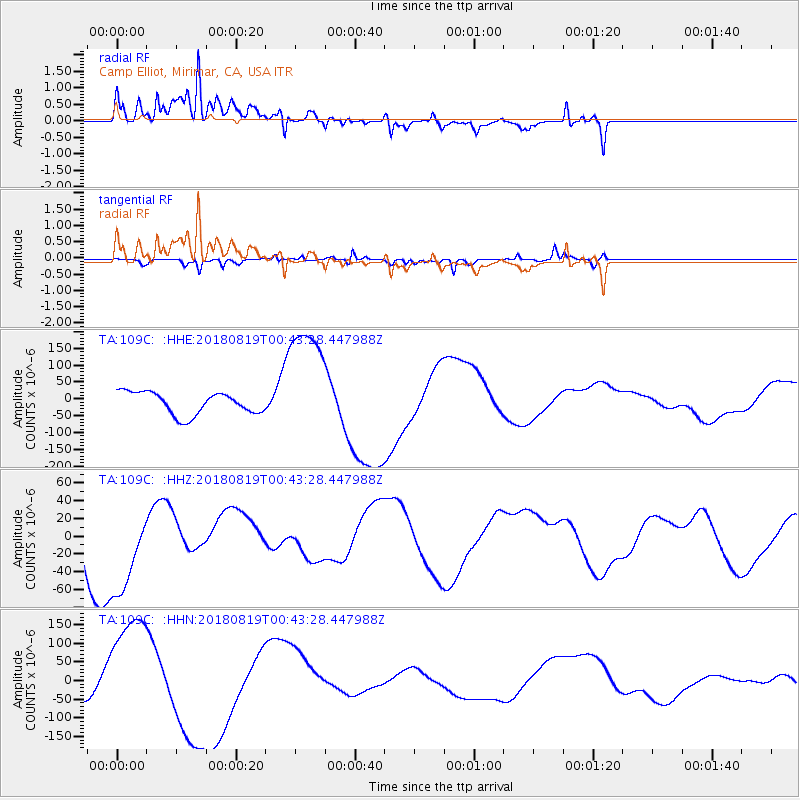
109C Camp Elliot, Mirimar, CA, USA - Earthquake Result Viewer
*The percent match for this event was below the threshold and hence no stack was calculated.
| Earthquake location: |
Fiji Islands Region |
| Earthquake latitude/longitude: |
-17.9/-178.2 |
| Earthquake time(UTC): |
2018/08/19 (231) 00:32:59 GMT |
| Earthquake Depth: |
520 km |
| Earthquake Magnitude: |
5.7 mb |
| Earthquake Catalog/Contributor: |
NEIC PDE/us |
|
| Network: |
TA USArray Transportable Network (new EarthScope stations) |
| Station: |
109C Camp Elliot, Mirimar, CA, USA |
| Lat/Lon: |
32.89 N/117.11 W |
| Elevation: |
150 m |
|
| Distance: |
77.2 deg |
| Az: |
49.056 deg |
| Baz: |
238.718 deg |
| Ray Param: |
$rayparam |
*The percent match for this event was below the threshold and hence was not used in the summary stack. |
|
| Radial Match: |
59.179493 % |
| Radial Bump: |
400 |
| Transverse Match: |
38.731472 % |
| Transverse Bump: |
286 |
| SOD ConfigId: |
13570011 |
| Insert Time: |
2019-04-30 21:22:45.170 +0000 |
| GWidth: |
2.5 |
| Max Bumps: |
400 |
| Tol: |
0.001 |
|
Signal To Noise
| Channel | StoN | STA | LTA |
| TA:109C: :HHZ:20180819T00:43:28.447988Z | 2.2199998 | 5.817854E-5 | 2.6206551E-5 |
| TA:109C: :HHN:20180819T00:43:28.447988Z | 5.06325 | 1.5621123E-4 | 3.085197E-5 |
| TA:109C: :HHE:20180819T00:43:28.447988Z | 5.547939 | 1.8331814E-4 | 3.304257E-5 |
| Arrivals |
| Ps | |
| PpPs | |
| PsPs/PpSs | |


