You are here: Home > Network List > US - United States National Seismic Network Stations List
> Station AMTX Amarillo, Texas, USA > Earthquake Result Viewer
AMTX Amarillo, Texas, USA - Earthquake Result Viewer
*The percent match for this event was below the threshold and hence no stack was calculated.
| Earthquake location: |
Northern Mid-Atlantic Ridge |
| Earthquake latitude/longitude: |
22.7/-45.1 |
| Earthquake time(UTC): |
2016/06/21 (173) 16:26:34 GMT |
| Earthquake Depth: |
10 km |
| Earthquake Magnitude: |
6.1 MWB |
| Earthquake Catalog/Contributor: |
NEIC PDE/NEIC COMCAT |
|
| Network: |
US United States National Seismic Network |
| Station: |
AMTX Amarillo, Texas, USA |
| Lat/Lon: |
34.53 N/101.41 W |
| Elevation: |
1010 m |
|
| Distance: |
50.2 deg |
| Az: |
296.717 deg |
| Baz: |
87.995 deg |
| Ray Param: |
$rayparam |
*The percent match for this event was below the threshold and hence was not used in the summary stack. |
|
| Radial Match: |
72.790634 % |
| Radial Bump: |
400 |
| Transverse Match: |
31.752272 % |
| Transverse Bump: |
400 |
| SOD ConfigId: |
1634031 |
| Insert Time: |
2016-07-05 16:32:03.528 +0000 |
| GWidth: |
2.5 |
| Max Bumps: |
400 |
| Tol: |
0.001 |
|
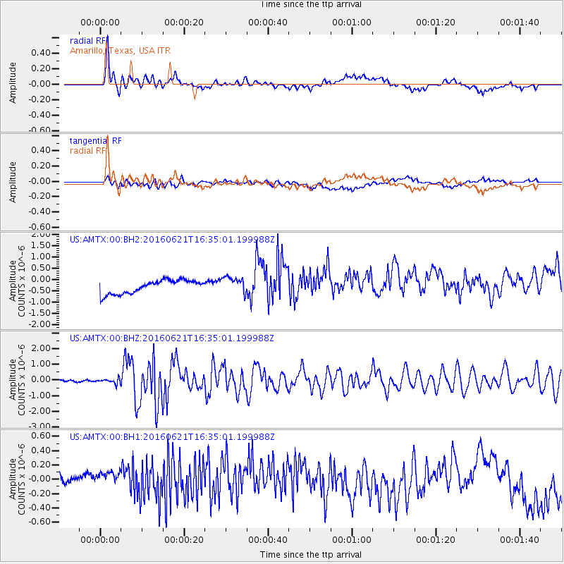
Signal To Noise
| Channel | StoN | STA | LTA |
| US:AMTX:00:BHZ:20160621T16:35:01.199988Z | 2.0606499 | 1.5725712E-7 | 7.6314336E-8 |
| US:AMTX:00:BH1:20160621T16:35:01.199988Z | 0.9311072 | 3.6877762E-7 | 3.9606354E-7 |
| US:AMTX:00:BH2:20160621T16:35:01.199988Z | 1.1764373 | 3.585033E-7 | 3.0473646E-7 |
| Arrivals |
| Ps | |
| PpPs | |
| PsPs/PpSs | |


