You are here: Home > Network List > TA - USArray Transportable Network (new EarthScope stations) Stations List
> Station F14A Wisdom, MT, USA > Earthquake Result Viewer
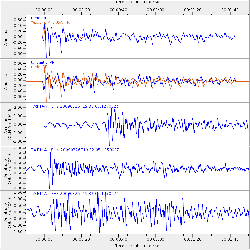
F14A Wisdom, MT, USA - Earthquake Result Viewer
*The percent match for this event was below the threshold and hence no stack was calculated.
| Earthquake location: |
Northwest Of Ryukyu Islands |
| Earthquake latitude/longitude: |
27.4/126.7 |
| Earthquake time(UTC): |
2009/03/26 (085) 19:19:59 GMT |
| Earthquake Depth: |
160 km |
| Earthquake Magnitude: |
5.6 MB, 5.9 MW, 5.9 MW |
| Earthquake Catalog/Contributor: |
WHDF/NEIC |
|
| Network: |
TA USArray Transportable Network (new EarthScope stations) |
| Station: |
F14A Wisdom, MT, USA |
| Lat/Lon: |
45.81 N/113.37 W |
| Elevation: |
1851 m |
|
| Distance: |
89.0 deg |
| Az: |
37.318 deg |
| Baz: |
309.599 deg |
| Ray Param: |
$rayparam |
*The percent match for this event was below the threshold and hence was not used in the summary stack. |
|
| Radial Match: |
89.21678 % |
| Radial Bump: |
400 |
| Transverse Match: |
76.644485 % |
| Transverse Bump: |
400 |
| SOD ConfigId: |
2658 |
| Insert Time: |
2010-03-06 14:20:01.755 +0000 |
| GWidth: |
2.5 |
| Max Bumps: |
400 |
| Tol: |
0.001 |
|
Signal To Noise
| Channel | StoN | STA | LTA |
| TA:F14A: :BHN:20090326T19:32:05.125002Z | 7.559981 | 9.883187E-7 | 1.3073033E-7 |
| TA:F14A: :BHE:20090326T19:32:05.125002Z | 1.772828 | 3.7026592E-7 | 2.0885608E-7 |
| TA:F14A: :BHZ:20090326T19:32:05.125002Z | 2.9730616 | 5.407909E-7 | 1.8189697E-7 |
| Arrivals |
| Ps | |
| PpPs | |
| PsPs/PpSs | |


