You are here: Home > Network List > TA - USArray Transportable Network (new EarthScope stations) Stations List
> Station F14A Wisdom, MT, USA > Earthquake Result Viewer
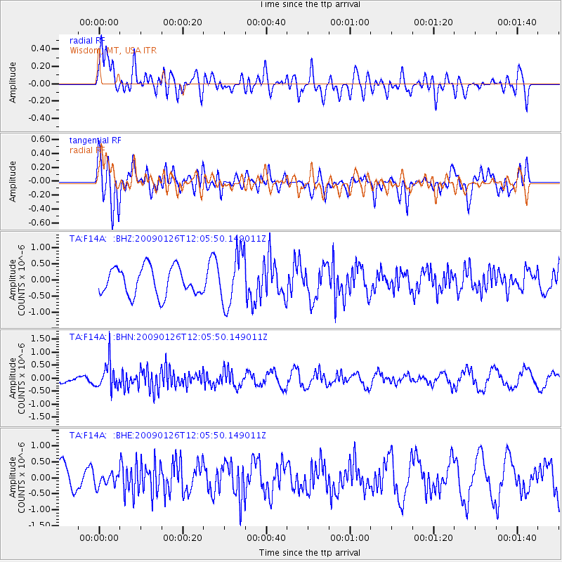
F14A Wisdom, MT, USA - Earthquake Result Viewer
*The percent match for this event was below the threshold and hence no stack was calculated.
| Earthquake location: |
Fiji Islands Region |
| Earthquake latitude/longitude: |
-17.8/-178.6 |
| Earthquake time(UTC): |
2009/01/26 (026) 11:54:39 GMT |
| Earthquake Depth: |
580 km |
| Earthquake Magnitude: |
5.5 MB, 5.8 MW, 5.8 MW |
| Earthquake Catalog/Contributor: |
WHDF/NEIC |
|
| Network: |
TA USArray Transportable Network (new EarthScope stations) |
| Station: |
F14A Wisdom, MT, USA |
| Lat/Lon: |
45.81 N/113.37 W |
| Elevation: |
1851 m |
|
| Distance: |
86.4 deg |
| Az: |
39.513 deg |
| Baz: |
240.078 deg |
| Ray Param: |
$rayparam |
*The percent match for this event was below the threshold and hence was not used in the summary stack. |
|
| Radial Match: |
53.32339 % |
| Radial Bump: |
400 |
| Transverse Match: |
59.7041 % |
| Transverse Bump: |
400 |
| SOD ConfigId: |
2658 |
| Insert Time: |
2010-03-06 14:20:16.012 +0000 |
| GWidth: |
2.5 |
| Max Bumps: |
400 |
| Tol: |
0.001 |
|
Signal To Noise
| Channel | StoN | STA | LTA |
| TA:F14A: :BHN:20090126T12:05:50.149011Z | 2.0694165 | 5.0563733E-7 | 2.443381E-7 |
| TA:F14A: :BHE:20090126T12:05:50.149011Z | 0.52305067 | 1.9971523E-7 | 3.8182768E-7 |
| TA:F14A: :BHZ:20090126T12:05:50.149011Z | 1.9801521 | 8.5024624E-7 | 4.293843E-7 |
| Arrivals |
| Ps | |
| PpPs | |
| PsPs/PpSs | |


