You are here: Home > Network List > TA - USArray Transportable Network (new EarthScope stations) Stations List
> Station B18K Kokolik River, AK, USA > Earthquake Result Viewer
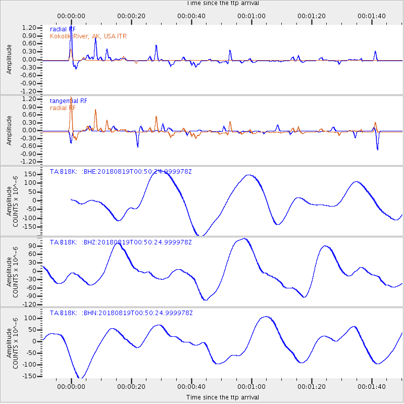
B18K Kokolik River, AK, USA - Earthquake Result Viewer
*The percent match for this event was below the threshold and hence no stack was calculated.
| Earthquake location: |
Fiji Islands Region |
| Earthquake latitude/longitude: |
-17.9/-178.0 |
| Earthquake time(UTC): |
2018/08/19 (231) 00:39:07 GMT |
| Earthquake Depth: |
576 km |
| Earthquake Magnitude: |
5.7 mb |
| Earthquake Catalog/Contributor: |
NEIC PDE/us |
|
| Network: |
TA USArray Transportable Network (new EarthScope stations) |
| Station: |
B18K Kokolik River, AK, USA |
| Lat/Lon: |
69.36 N/161.80 W |
| Elevation: |
222 m |
|
| Distance: |
87.8 deg |
| Az: |
5.675 deg |
| Baz: |
195.402 deg |
| Ray Param: |
$rayparam |
*The percent match for this event was below the threshold and hence was not used in the summary stack. |
|
| Radial Match: |
75.341995 % |
| Radial Bump: |
376 |
| Transverse Match: |
29.33254 % |
| Transverse Bump: |
126 |
| SOD ConfigId: |
13570011 |
| Insert Time: |
2019-04-30 21:29:43.770 +0000 |
| GWidth: |
2.5 |
| Max Bumps: |
400 |
| Tol: |
0.001 |
|
Signal To Noise
| Channel | StoN | STA | LTA |
| TA:B18K: :BHZ:20180819T00:50:24.999978Z | 1.7816032 | 2.2565193E-5 | 1.2665667E-5 |
| TA:B18K: :BHN:20180819T00:50:24.999978Z | 5.002462 | 1.4197592E-4 | 2.8381208E-5 |
| TA:B18K: :BHE:20180819T00:50:24.999978Z | 4.680941 | 1.8174834E-4 | 3.8827307E-5 |
| Arrivals |
| Ps | |
| PpPs | |
| PsPs/PpSs | |


