You are here: Home > Network List > TA - USArray Transportable Network (new EarthScope stations) Stations List
> Station D25K Kavik River, AK, USA > Earthquake Result Viewer
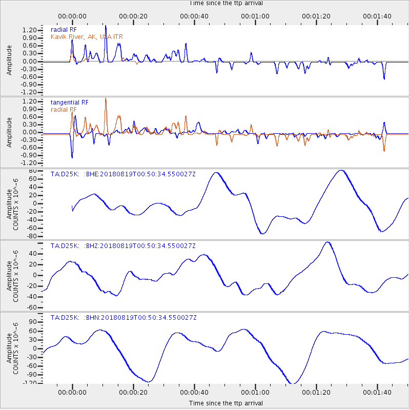
D25K Kavik River, AK, USA - Earthquake Result Viewer
*The percent match for this event was below the threshold and hence no stack was calculated.
| Earthquake location: |
Fiji Islands Region |
| Earthquake latitude/longitude: |
-17.9/-178.0 |
| Earthquake time(UTC): |
2018/08/19 (231) 00:39:07 GMT |
| Earthquake Depth: |
576 km |
| Earthquake Magnitude: |
5.7 mb |
| Earthquake Catalog/Contributor: |
NEIC PDE/us |
|
| Network: |
TA USArray Transportable Network (new EarthScope stations) |
| Station: |
D25K Kavik River, AK, USA |
| Lat/Lon: |
69.32 N/146.38 W |
| Elevation: |
770 m |
|
| Distance: |
89.9 deg |
| Az: |
10.73 deg |
| Baz: |
209.938 deg |
| Ray Param: |
$rayparam |
*The percent match for this event was below the threshold and hence was not used in the summary stack. |
|
| Radial Match: |
64.329636 % |
| Radial Bump: |
350 |
| Transverse Match: |
46.339657 % |
| Transverse Bump: |
398 |
| SOD ConfigId: |
13570011 |
| Insert Time: |
2019-04-30 21:29:53.602 +0000 |
| GWidth: |
2.5 |
| Max Bumps: |
400 |
| Tol: |
0.001 |
|
Signal To Noise
| Channel | StoN | STA | LTA |
| TA:D25K: :BHZ:20180819T00:50:34.550027Z | 1.6685942 | 1.9610054E-5 | 1.175244E-5 |
| TA:D25K: :BHN:20180819T00:50:34.550027Z | 2.271941 | 3.5434197E-5 | 1.5596443E-5 |
| TA:D25K: :BHE:20180819T00:50:34.550027Z | 0.7691583 | 1.239595E-5 | 1.6116253E-5 |
| Arrivals |
| Ps | |
| PpPs | |
| PsPs/PpSs | |


