You are here: Home > Network List > TA - USArray Transportable Network (new EarthScope stations) Stations List
> Station F21K Alatna River, AK, USA > Earthquake Result Viewer
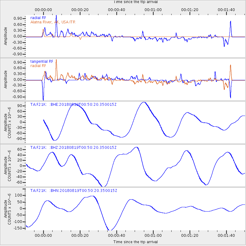
F21K Alatna River, AK, USA - Earthquake Result Viewer
*The percent match for this event was below the threshold and hence no stack was calculated.
| Earthquake location: |
Fiji Islands Region |
| Earthquake latitude/longitude: |
-17.9/-178.0 |
| Earthquake time(UTC): |
2018/08/19 (231) 00:39:07 GMT |
| Earthquake Depth: |
576 km |
| Earthquake Magnitude: |
5.7 mb |
| Earthquake Catalog/Contributor: |
NEIC PDE/us |
|
| Network: |
TA USArray Transportable Network (new EarthScope stations) |
| Station: |
F21K Alatna River, AK, USA |
| Lat/Lon: |
67.22 N/153.48 W |
| Elevation: |
597 m |
|
| Distance: |
86.8 deg |
| Az: |
9.308 deg |
| Baz: |
203.298 deg |
| Ray Param: |
$rayparam |
*The percent match for this event was below the threshold and hence was not used in the summary stack. |
|
| Radial Match: |
47.54788 % |
| Radial Bump: |
400 |
| Transverse Match: |
41.243927 % |
| Transverse Bump: |
400 |
| SOD ConfigId: |
13570011 |
| Insert Time: |
2019-04-30 21:30:03.529 +0000 |
| GWidth: |
2.5 |
| Max Bumps: |
400 |
| Tol: |
0.001 |
|
Signal To Noise
| Channel | StoN | STA | LTA |
| TA:F21K: :BHZ:20180819T00:50:20.350015Z | 2.0743625 | 4.019475E-5 | 1.9376917E-5 |
| TA:F21K: :BHN:20180819T00:50:20.350015Z | 0.7516303 | 5.5689343E-5 | 7.4091404E-5 |
| TA:F21K: :BHE:20180819T00:50:20.350015Z | 0.6720851 | 4.6361652E-5 | 6.898181E-5 |
| Arrivals |
| Ps | |
| PpPs | |
| PsPs/PpSs | |


