You are here: Home > Network List > TA - USArray Transportable Network (new EarthScope stations) Stations List
> Station G31M Satah River, YT, CAN > Earthquake Result Viewer
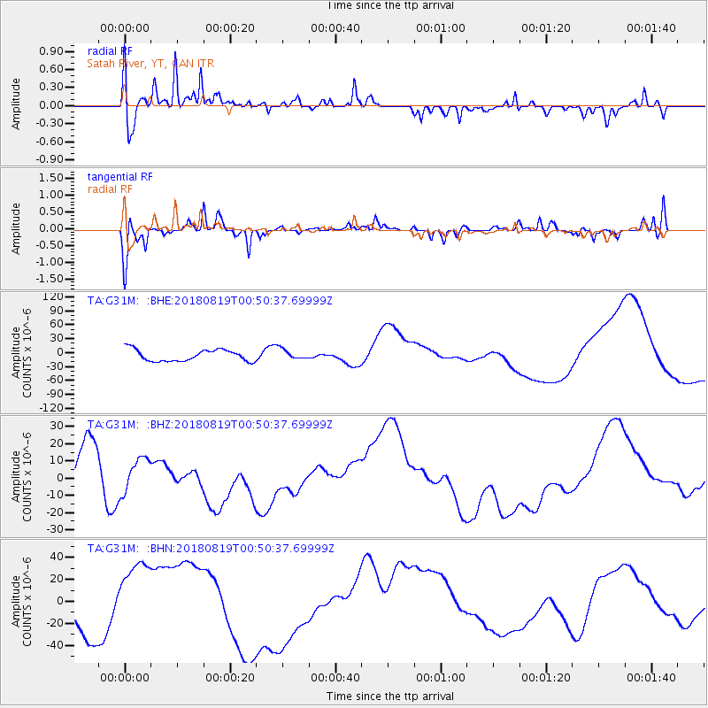
G31M Satah River, YT, CAN - Earthquake Result Viewer
*The percent match for this event was below the threshold and hence no stack was calculated.
| Earthquake location: |
Fiji Islands Region |
| Earthquake latitude/longitude: |
-17.9/-178.0 |
| Earthquake time(UTC): |
2018/08/19 (231) 00:39:07 GMT |
| Earthquake Depth: |
576 km |
| Earthquake Magnitude: |
5.7 mb |
| Earthquake Catalog/Contributor: |
NEIC PDE/us |
|
| Network: |
TA USArray Transportable Network (new EarthScope stations) |
| Station: |
G31M Satah River, YT, CAN |
| Lat/Lon: |
66.92 N/134.27 W |
| Elevation: |
61 m |
|
| Distance: |
90.6 deg |
| Az: |
15.81 deg |
| Baz: |
221.15 deg |
| Ray Param: |
$rayparam |
*The percent match for this event was below the threshold and hence was not used in the summary stack. |
|
| Radial Match: |
46.06697 % |
| Radial Bump: |
356 |
| Transverse Match: |
58.259018 % |
| Transverse Bump: |
382 |
| SOD ConfigId: |
13570011 |
| Insert Time: |
2019-04-30 21:30:12.759 +0000 |
| GWidth: |
2.5 |
| Max Bumps: |
400 |
| Tol: |
0.001 |
|
Signal To Noise
| Channel | StoN | STA | LTA |
| TA:G31M: :BHZ:20180819T00:50:37.69999Z | 1.0129083 | 9.563469E-6 | 9.441594E-6 |
| TA:G31M: :BHN:20180819T00:50:37.69999Z | 2.4576628 | 3.6741298E-5 | 1.4949689E-5 |
| TA:G31M: :BHE:20180819T00:50:37.69999Z | 0.8837448 | 1.0917386E-5 | 1.235355E-5 |
| Arrivals |
| Ps | |
| PpPs | |
| PsPs/PpSs | |


