You are here: Home > Network List > TA - USArray Transportable Network (new EarthScope stations) Stations List
> Station F14A Wisdom, MT, USA > Earthquake Result Viewer
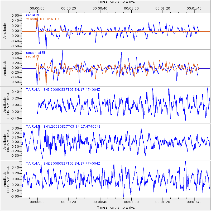
F14A Wisdom, MT, USA - Earthquake Result Viewer
*The percent match for this event was below the threshold and hence no stack was calculated.
| Earthquake location: |
Kuril Islands |
| Earthquake latitude/longitude: |
46.7/152.5 |
| Earthquake time(UTC): |
2008/08/27 (240) 05:24:41 GMT |
| Earthquake Depth: |
65 km |
| Earthquake Magnitude: |
5.5 MB, 5.4 MW, 5.3 MW |
| Earthquake Catalog/Contributor: |
WHDF/NEIC |
|
| Network: |
TA USArray Transportable Network (new EarthScope stations) |
| Station: |
F14A Wisdom, MT, USA |
| Lat/Lon: |
45.81 N/113.37 W |
| Elevation: |
1851 m |
|
| Distance: |
61.1 deg |
| Az: |
52.858 deg |
| Baz: |
308.366 deg |
| Ray Param: |
$rayparam |
*The percent match for this event was below the threshold and hence was not used in the summary stack. |
|
| Radial Match: |
73.87226 % |
| Radial Bump: |
400 |
| Transverse Match: |
62.20979 % |
| Transverse Bump: |
400 |
| SOD ConfigId: |
2504 |
| Insert Time: |
2010-03-06 14:20:42.502 +0000 |
| GWidth: |
2.5 |
| Max Bumps: |
400 |
| Tol: |
0.001 |
|
Signal To Noise
| Channel | StoN | STA | LTA |
| TA:F14A: :BHN:20080827T05:34:17.474004Z | 2.4184082 | 2.130192E-7 | 8.80824E-8 |
| TA:F14A: :BHE:20080827T05:34:17.474004Z | 1.5751042 | 2.1430091E-7 | 1.3605508E-7 |
| TA:F14A: :BHZ:20080827T05:34:17.474004Z | 1.2344497 | 1.2851987E-7 | 1.0411106E-7 |
| Arrivals |
| Ps | |
| PpPs | |
| PsPs/PpSs | |


