You are here: Home > Network List > TA - USArray Transportable Network (new EarthScope stations) Stations List
> Station R33M Jennings River, BC, CAN > Earthquake Result Viewer
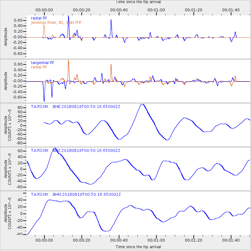
R33M Jennings River, BC, CAN - Earthquake Result Viewer
*The percent match for this event was below the threshold and hence no stack was calculated.
| Earthquake location: |
Fiji Islands Region |
| Earthquake latitude/longitude: |
-17.9/-178.0 |
| Earthquake time(UTC): |
2018/08/19 (231) 00:39:07 GMT |
| Earthquake Depth: |
576 km |
| Earthquake Magnitude: |
5.7 mb |
| Earthquake Catalog/Contributor: |
NEIC PDE/us |
|
| Network: |
TA USArray Transportable Network (new EarthScope stations) |
| Station: |
R33M Jennings River, BC, CAN |
| Lat/Lon: |
59.39 N/130.97 W |
| Elevation: |
1437 m |
|
| Distance: |
86.0 deg |
| Az: |
22.039 deg |
| Baz: |
224.286 deg |
| Ray Param: |
$rayparam |
*The percent match for this event was below the threshold and hence was not used in the summary stack. |
|
| Radial Match: |
70.643074 % |
| Radial Bump: |
273 |
| Transverse Match: |
60.38074 % |
| Transverse Bump: |
366 |
| SOD ConfigId: |
13570011 |
| Insert Time: |
2019-04-30 21:30:57.052 +0000 |
| GWidth: |
2.5 |
| Max Bumps: |
400 |
| Tol: |
0.001 |
|
Signal To Noise
| Channel | StoN | STA | LTA |
| TA:R33M: :BHZ:20180819T00:50:16.650002Z | 1.9055935 | 3.9065155E-5 | 2.0500256E-5 |
| TA:R33M: :BHN:20180819T00:50:16.650002Z | 1.3622566 | 4.574977E-5 | 3.3583812E-5 |
| TA:R33M: :BHE:20180819T00:50:16.650002Z | 0.66465235 | 1.3213651E-5 | 1.9880545E-5 |
| Arrivals |
| Ps | |
| PpPs | |
| PsPs/PpSs | |


