You are here: Home > Network List > C1 - Red Sismologica Nacional Stations List
> Station MT15 Las Vizcachas > Earthquake Result Viewer
MT15 Las Vizcachas - Earthquake Result Viewer
| Earthquake location: |
Fiji Islands Region |
| Earthquake latitude/longitude: |
-18.2/-178.1 |
| Earthquake time(UTC): |
2018/08/19 (231) 00:55:44 GMT |
| Earthquake Depth: |
538 km |
| Earthquake Magnitude: |
5.6 mb |
| Earthquake Catalog/Contributor: |
NEIC PDE/us |
|
| Network: |
C1 Red Sismologica Nacional |
| Station: |
MT15 Las Vizcachas |
| Lat/Lon: |
33.60 S/70.51 W |
| Elevation: |
784 m |
|
| Distance: |
93.9 deg |
| Az: |
127.111 deg |
| Baz: |
245.245 deg |
| Ray Param: |
0.040661976 |
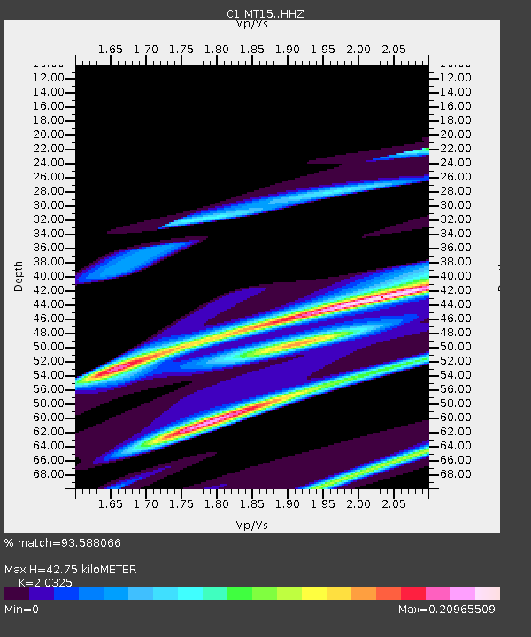
| Estimated Moho Depth: |
42.75 km |
| Estimated Crust Vp/Vs: |
2.03 |
| Assumed Crust Vp: |
6.481 km/s |
| Estimated Crust Vs: |
3.189 km/s |
| Estimated Crust Poisson's Ratio: |
0.34 |
|
| Radial Match: |
93.588066 % |
| Radial Bump: |
269 |
| Transverse Match: |
77.75886 % |
| Transverse Bump: |
400 |
| SOD ConfigId: |
13570011 |
| Insert Time: |
2019-04-30 21:33:48.939 +0000 |
| GWidth: |
2.5 |
| Max Bumps: |
400 |
| Tol: |
0.001 |
|

Signal To Noise
| Channel | StoN | STA | LTA |
| C1:MT15: :HHZ:20180819T01:07:33.233Z | 2.0635478 | 2.4872303E-5 | 1.2053175E-5 |
| C1:MT15: :HHN:20180819T01:07:33.233Z | 1.4297091 | 1.1148047E-5 | 7.797424E-6 |
| C1:MT15: :HHE:20180819T01:07:33.233Z | 1.5440321 | 1.554916E-5 | 1.0070489E-5 |
| Arrivals |
| Ps | 6.9 SECOND |
| PpPs | 20 SECOND |
| PsPs/PpSs | 27 SECOND |


