You are here: Home > Network List > TA - USArray Transportable Network (new EarthScope stations) Stations List
> Station F21K Alatna River, AK, USA > Earthquake Result Viewer
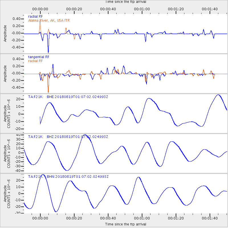
F21K Alatna River, AK, USA - Earthquake Result Viewer
*The percent match for this event was below the threshold and hence no stack was calculated.
| Earthquake location: |
Fiji Islands Region |
| Earthquake latitude/longitude: |
-18.2/-178.1 |
| Earthquake time(UTC): |
2018/08/19 (231) 00:55:44 GMT |
| Earthquake Depth: |
538 km |
| Earthquake Magnitude: |
5.6 mb |
| Earthquake Catalog/Contributor: |
NEIC PDE/us |
|
| Network: |
TA USArray Transportable Network (new EarthScope stations) |
| Station: |
F21K Alatna River, AK, USA |
| Lat/Lon: |
67.22 N/153.48 W |
| Elevation: |
597 m |
|
| Distance: |
87.1 deg |
| Az: |
9.346 deg |
| Baz: |
203.354 deg |
| Ray Param: |
$rayparam |
*The percent match for this event was below the threshold and hence was not used in the summary stack. |
|
| Radial Match: |
83.369125 % |
| Radial Bump: |
313 |
| Transverse Match: |
67.92436 % |
| Transverse Bump: |
366 |
| SOD ConfigId: |
13570011 |
| Insert Time: |
2019-04-30 21:36:25.255 +0000 |
| GWidth: |
2.5 |
| Max Bumps: |
400 |
| Tol: |
0.001 |
|
Signal To Noise
| Channel | StoN | STA | LTA |
| TA:F21K: :BHZ:20180819T01:07:02.024993Z | 0.70052636 | 1.604123E-5 | 2.2898823E-5 |
| TA:F21K: :BHN:20180819T01:07:02.024993Z | 2.5754693 | 2.5937294E-5 | 1.0070899E-5 |
| TA:F21K: :BHE:20180819T01:07:02.024993Z | 0.4375711 | 3.4234522E-6 | 7.823762E-6 |
| Arrivals |
| Ps | |
| PpPs | |
| PsPs/PpSs | |


