You are here: Home > Network List > TA - USArray Transportable Network (new EarthScope stations) Stations List
> Station Z17A San Carlos High School, San Carlos, AZ, USA > Earthquake Result Viewer
Z17A San Carlos High School, San Carlos, AZ, USA - Earthquake Result Viewer

| Earthquake location: |
Kermadec Islands, New Zealand |
| Earthquake latitude/longitude: |
-29.8/-177.7 |
| Earthquake time(UTC): |
2008/09/29 (273) 15:19:31 GMT |
| Earthquake Depth: |
36 km |
| Earthquake Magnitude: |
6.5 MB, 6.7 MS, 7.0 MW, 7.0 MW |
| Earthquake Catalog/Contributor: |
WHDF/NEIC |
|
| Network: |
TA USArray Transportable Network (new EarthScope stations) |
| Station: |
Z17A San Carlos High School, San Carlos, AZ, USA |
| Lat/Lon: |
33.30 N/110.47 W |
| Elevation: |
846 m |
|
| Distance: |
89.3 deg |
| Az: |
50.552 deg |
| Baz: |
233.298 deg |
| Ray Param: |
0.04190662 |
| Estimated Moho Depth: |
32.0 km |
| Estimated Crust Vp/Vs: |
1.88 |
| Assumed Crust Vp: |
6.276 km/s |
| Estimated Crust Vs: |
3.343 km/s |
| Estimated Crust Poisson's Ratio: |
0.30 |
|
| Radial Match: |
92.97193 % |
| Radial Bump: |
400 |
| Transverse Match: |
92.38615 % |
| Transverse Bump: |
400 |
| SOD ConfigId: |
2560 |
| Insert Time: |
2010-03-06 14:21:21.414 +0000 |
| GWidth: |
2.5 |
| Max Bumps: |
400 |
| Tol: |
0.001 |
|
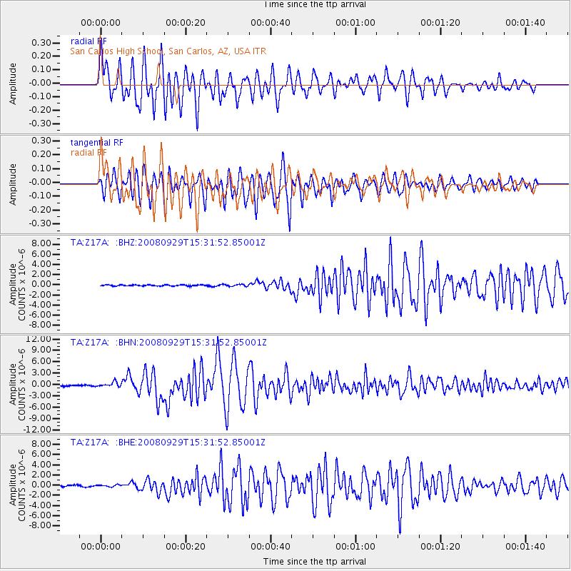
Signal To Noise
| Channel | StoN | STA | LTA |
| TA:Z17A: :BHN:20080929T15:31:52.85001Z | 5.099461 | 6.3024754E-7 | 1.2359101E-7 |
| TA:Z17A: :BHE:20080929T15:31:52.85001Z | 1.5753868 | 1.8341018E-7 | 1.16422314E-7 |
| TA:Z17A: :BHZ:20080929T15:31:52.85001Z | 1.666114 | 1.8239732E-7 | 1.094747E-7 |
| Arrivals |
| Ps | 4.6 SECOND |
| PpPs | 14 SECOND |
| PsPs/PpSs | 19 SECOND |


