You are here: Home > Network List > TA - USArray Transportable Network (new EarthScope stations) Stations List
> Station Z17A San Carlos High School, San Carlos, AZ, USA > Earthquake Result Viewer
Z17A San Carlos High School, San Carlos, AZ, USA - Earthquake Result Viewer

| Earthquake location: |
South Of Panama |
| Earthquake latitude/longitude: |
6.9/-82.4 |
| Earthquake time(UTC): |
2008/01/24 (024) 04:12:13 GMT |
| Earthquake Depth: |
10 km |
| Earthquake Magnitude: |
5.8 MW, 5.3 MS, 5.3 MB, 5.8 MW |
| Earthquake Catalog/Contributor: |
WHDF/NEIC |
|
| Network: |
TA USArray Transportable Network (new EarthScope stations) |
| Station: |
Z17A San Carlos High School, San Carlos, AZ, USA |
| Lat/Lon: |
33.30 N/110.47 W |
| Elevation: |
846 m |
|
| Distance: |
37.0 deg |
| Az: |
319.005 deg |
| Baz: |
128.96 deg |
| Ray Param: |
0.0764008 |
| Estimated Moho Depth: |
11.25 km |
| Estimated Crust Vp/Vs: |
1.60 |
| Assumed Crust Vp: |
6.276 km/s |
| Estimated Crust Vs: |
3.922 km/s |
| Estimated Crust Poisson's Ratio: |
0.18 |
|
| Radial Match: |
80.96249 % |
| Radial Bump: |
370 |
| Transverse Match: |
76.59079 % |
| Transverse Bump: |
381 |
| SOD ConfigId: |
2564 |
| Insert Time: |
2010-03-06 14:21:30.667 +0000 |
| GWidth: |
2.5 |
| Max Bumps: |
400 |
| Tol: |
0.001 |
|
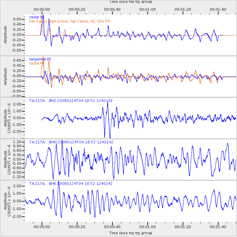
Signal To Noise
| Channel | StoN | STA | LTA |
| TA:Z17A: :BHN:20080124T04:18:52.124014Z | 1.9344044 | 4.429898E-7 | 2.2900579E-7 |
| TA:Z17A: :BHE:20080124T04:18:52.124014Z | 0.7966018 | 3.351408E-7 | 4.2071312E-7 |
| TA:Z17A: :BHZ:20080124T04:18:52.124014Z | 1.7426429 | 5.0020424E-7 | 2.870377E-7 |
| Arrivals |
| Ps | 1.2 SECOND |
| PpPs | 4.3 SECOND |
| PsPs/PpSs | 5.5 SECOND |


