You are here: Home > Network List > TA - USArray Transportable Network (new EarthScope stations) Stations List
> Station Z17A San Carlos High School, San Carlos, AZ, USA > Earthquake Result Viewer
Z17A San Carlos High School, San Carlos, AZ, USA - Earthquake Result Viewer
| Earthquake location: |
Fox Islands, Aleutian Islands |
| Earthquake latitude/longitude: |
52.5/-168.0 |
| Earthquake time(UTC): |
2007/07/15 (196) 13:08:00 GMT |
| Earthquake Depth: |
10 km |
| Earthquake Magnitude: |
5.8 MB, 5.9 MS, 6.1 MW, 6.0 MW |
| Earthquake Catalog/Contributor: |
WHDF/NEIC |
|
| Network: |
TA USArray Transportable Network (new EarthScope stations) |
| Station: |
Z17A San Carlos High School, San Carlos, AZ, USA |
| Lat/Lon: |
33.30 N/110.47 W |
| Elevation: |
846 m |
|
| Distance: |
45.0 deg |
| Az: |
91.709 deg |
| Baz: |
313.118 deg |
| Ray Param: |
0.071559034 |
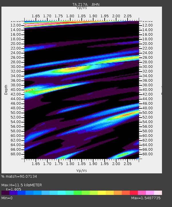
| Estimated Moho Depth: |
11.5 km |
| Estimated Crust Vp/Vs: |
1.61 |
| Assumed Crust Vp: |
6.276 km/s |
| Estimated Crust Vs: |
3.91 km/s |
| Estimated Crust Poisson's Ratio: |
0.18 |
|
| Radial Match: |
90.07134 % |
| Radial Bump: |
400 |
| Transverse Match: |
84.56072 % |
| Transverse Bump: |
400 |
| SOD ConfigId: |
2564 |
| Insert Time: |
2010-03-06 14:22:06.669 +0000 |
| GWidth: |
2.5 |
| Max Bumps: |
400 |
| Tol: |
0.001 |
|
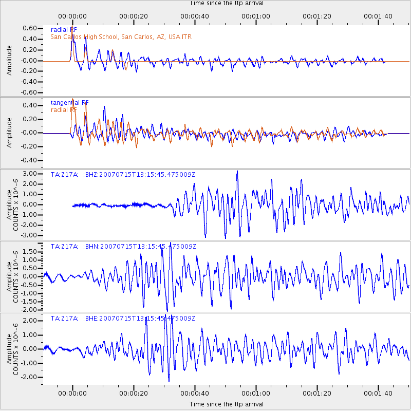
Signal To Noise
| Channel | StoN | STA | LTA |
| TA:Z17A: :BHN:20070715T13:15:45.475009Z | 1.0672497 | 1.2249814E-7 | 1.1477927E-7 |
| TA:Z17A: :BHE:20070715T13:15:45.475009Z | 2.1551523 | 2.2295565E-7 | 1.03452386E-7 |
| TA:Z17A: :BHZ:20070715T13:15:45.475009Z | 4.5690804 | 4.0745405E-7 | 8.917638E-8 |
| Arrivals |
| Ps | 1.2 SECOND |
| PpPs | 4.5 SECOND |
| PsPs/PpSs | 5.6 SECOND |


