You are here: Home > Network List > TA - USArray Transportable Network (new EarthScope stations) Stations List
> Station D25K Kavik River, AK, USA > Earthquake Result Viewer
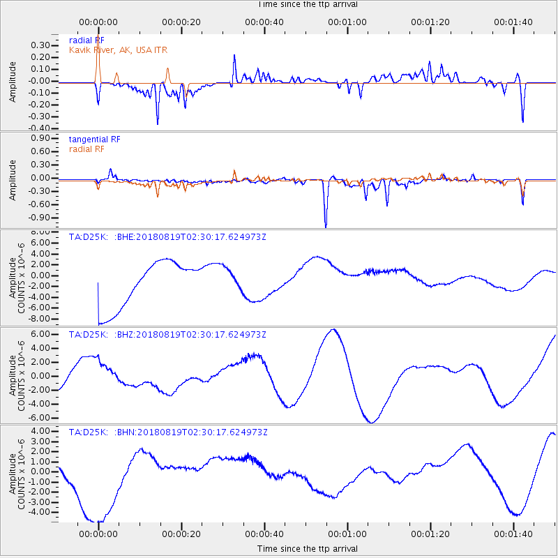
D25K Kavik River, AK, USA - Earthquake Result Viewer
*The percent match for this event was below the threshold and hence no stack was calculated.
| Earthquake location: |
Fiji Islands Region |
| Earthquake latitude/longitude: |
-18.3/-178.4 |
| Earthquake time(UTC): |
2018/08/19 (231) 02:18:52 GMT |
| Earthquake Depth: |
618 km |
| Earthquake Magnitude: |
5.7 mb |
| Earthquake Catalog/Contributor: |
NEIC PDE/us |
|
| Network: |
TA USArray Transportable Network (new EarthScope stations) |
| Station: |
D25K Kavik River, AK, USA |
| Lat/Lon: |
69.32 N/146.38 W |
| Elevation: |
770 m |
|
| Distance: |
90.3 deg |
| Az: |
10.843 deg |
| Baz: |
210.214 deg |
| Ray Param: |
$rayparam |
*The percent match for this event was below the threshold and hence was not used in the summary stack. |
|
| Radial Match: |
61.08425 % |
| Radial Bump: |
400 |
| Transverse Match: |
56.115612 % |
| Transverse Bump: |
400 |
| SOD ConfigId: |
13570011 |
| Insert Time: |
2019-04-30 21:43:06.780 +0000 |
| GWidth: |
2.5 |
| Max Bumps: |
400 |
| Tol: |
0.001 |
|
Signal To Noise
| Channel | StoN | STA | LTA |
| TA:D25K: :BHZ:20180819T02:30:17.624973Z | 1.4376118 | 1.9105137E-6 | 1.3289497E-6 |
| TA:D25K: :BHN:20180819T02:30:17.624973Z | 2.6309247 | 5.801997E-6 | 2.205307E-6 |
| TA:D25K: :BHE:20180819T02:30:17.624973Z | 0.5664052 | 2.3698715E-6 | 4.1840567E-6 |
| Arrivals |
| Ps | |
| PpPs | |
| PsPs/PpSs | |


